2012-04-01 34 -89
| Sun 1 Apr 2012 in 34,-89: 34.6803372, -89.2810392 geohashing.info google osm bing/os kml crox |
Location
Just off a dirt road in Holly Springs National Forest
Participants
Amanda and Mayor
Plans
Plan was to drive down in the afternoon and bring along some sandwiches and whatnot for a picnic geohash. Nothing too intense. We brought Amanda's husky Smokey as well.
Expedition
Everything went as planned up until we got off the freeway. Apparently a bridge was out, and a primary highway was completely blocked off. The problem was that there was no indication of a detour or anything. Just, "ROAD CLOSED, GO AWAY, GRRR." So first we tried to find us a detour. That took us through some pretty backwoods neighborhoods. Amanda thought it was creepy, but I thought it was fine. My argument: "Look at all the happy yard ornaments, kids playing-- look a puppy!" Her argument: "It is wooded and secluded and there is an abandoned teddy bear in the middle of the road." Anyway, we were pretty sure we made some really good progress and that we were going to come out ahead of the road blockage, but then once we got back to the highway we realized we'd gone in a complete circle and were right back were we started.
Time for plan B. We sat in the car and debated asking the locals. In a reverse stereotype, I thought it would help, but Amanda didn't want to. There were some women outside of a house playing with their kids; not even any scary redneck dudes, but Amanda was still not convinced. Just as I was about to get out of the car-- "Wait wait wait! What's that car doing...?" It was going around the road barrier! "Okay, let's do that!" So we did. And it got us nowhere. About a mile ahead, there was a bridge that was completely blocked (but completely intact-- Why was it closed? I don't know!! It was so dumb. Probably some stupid safety issue or something. Harumph.), with no way of going around.
So we had to backtrack, hop on the freeway, get off on the next exit, and work backwards. That worked just fine, and soon enough we were making our way through some very rural farmland all nestled between rolling hills and country side. Very pretty, very idyllic. The road turned to gravel, and soon enough we were as close to the hash point as we could drive. And then... Uh oh. A gate and a big ol' red "NO TRESPASSING" sign. Balls! So close. Amanda insisted the hash point was just before the gate, so I pulled out the GPS to be sure. Nope. Quite a ways farther.
While investigating the gate, we heard some rifle shots (definitely just target practice, and rather far away, but still...), and Smokey was kinda nervous, so we decided not to have our picnic there. We got back in the car and headed home, eating our sandwiches on the way... Sandwiches of Defeat.
Photos
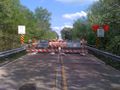
This was the second blockade, directly in front of the bridge.
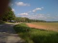
Field of flowers
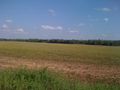
And some farms
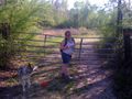
Smokey seems okay with it.
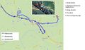
Kindof a crappy substitute for a tracklog, but too bad, deal with it.


Achievements
Mayor and Amanda earned the No trespassing consolation prize
|