2012-04-05 58 7
| Thu 5 Apr 2012 in 58,7: 58.4048311, 7.2127302 geohashing.info google osm bing/os kml crox |
Location
In the woods near the top of Flateknuten 3km north of Øvre Birkeland.
Participants
- Oddmund
- Ståle
Plans
Expedition
Oddmund and Ståle set out from Vigeland on the newly built E39 towards Lyndal and sent this from the Geohash Droid app:
- Oddmund and Ståle is giving this hash a shot. 28km left. We brought boots. -- Oddmunds @58.1503,7.1528 17:31, 05 April 2012 (GMT+02:00)
In Lyngdal we continued up the 43 following along Lygna.
We had a brief stop in Kvås, marveling at Kvåsfossen (waterfall).
We took off the 43 in Øvre Birkeland, followed the 751 briefly before we took off at Lykke bru (tiny bridge) and started following a windy road up into the hillside.
We parked the car about 1 km from the hash and walked along a tractor road until it faded into marsh 400m from the hash. From there it was a steep ascent until we reached the Flateknuten peak at 510 meters height (according to our gps (the maps say 497m)). When we found it it started snowing and when we came back to the car the snow and wind was so unpleasant that we were glad we were going home again.
Photos
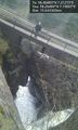
Awesome waterfall at Kvåsfossen @58.2649,7.1901

At the peak. 500m above the sea. @58.4047,7.2089
Success! @58.4048,7.2128


