2012-04-20 48 8
| Fri 20 Apr 2012 in 48,8: 48.5094327, 8.9102206 geohashing.info google osm bing/os kml crox |
Contents
[hide]Location
An abandoned forest track between the villages Seebronn, Oberndorf and Wendelsheim, which all belong to Rottenburg am Neckar.
Participants
Ekorren was there.
Expedition
Well, it was almost too close not to go, and I had to go to some shop along the way anyway, and it looked easy... So I did go.
When reaching the hash forest I noticed that some tracks were missing on OSM, so I took the time and mapped a few more out. This included the leftovers of the track running right through the hash which I considered being still good enough to be marked as a path. Which turned out to end in the middle of the forest. It would be interesting to see if, now that that path appears as a dead end road on OSM, people will actually walk out there just to see why there even is that path mapped and whether it needs to be completed...
Ok, there's now that OSM achievement. I could propably take it for about one half of my expeditions, and on some expeditions I did really serious work (like mapping out half villages and longer bike trails) but at that time the achievement was still refused. So since one has to be the one, I'll take it for this one. Not so much for the hash path, though, more for the rest of the work I did along the way.
Ekorren earned the OpenStreetMap achievement
|
Gallery
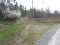
Once a track, always a track on some maps...
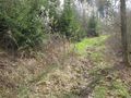
The hashpoint. Yes, this is still that track.

Coordinates reached
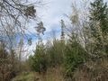
View from hash
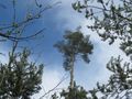
Around the hash