2012-05-12 32 -97
From Geohashing
| Sat 12 May 2012 in 32,-97: 32.9260412, -97.3618228 geohashing.info google osm bing/os kml crox |
Location
A field in a subdivision in Haslet, very close to Highway 81 and only a few miles west of Interstate 35W.
Participants
Plans
Not much planning involved, more of a spur of the moment thing. Noticed the hash was close in the morning.
Expedition
Left house in Shady Shores (23 miles from hash) at 1:15 p.m. and arrived in Haslet at 2:00. It was very easy to locate and reach as it was close to the highway and only about 200 feet from a road in the subdivision. Some mud issues were encountered as there had been recent rain, but nothing that could hinder the progress significantly.
Photos

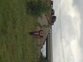
Me at the coordinates with nice freight train in the background.
'Nother one of me, this time from about 100 ft. away with highway 81 as the backdrop.

.jpg)
Achievements
Neimster earned the Land geohash achievement
|
Neimster achieved level 1 of the Minesweeper Geohash achievement
|