2012-06-07 33 -116
| Thu 7 Jun 2012 in 33,-116: 33.2988322, -116.5258616 geohashing.info google osm bing/os kml crox |
Location
Almost exactly one mile in elevation on the side of Hot Springs Mountain, amid a burned-out manzanita grove
Participants
Expedition
The hasher drove northward and eastward on the 67, 78, and 79 highways from Poway to Warner Springs, at which point the hasher turned eastward along Camino San Ignacio. The road entered the Los Coyotes Indian Reservation; after passing through the reservation, the pavement turned to dirt as the road skirted around the south and east faces of Hot Springs Mountain.
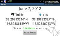
The road eventually passed within 200m of the hashpoint. The hasher parked the vehicle and proceeded on foot through brambly brush and burnt manzanita westward up the side of the mountain to the hashpoint, recorded the success via Geohash Droid screenshot, took pictures for a panorama, and exited.
Photos
Achievements
LucasBrown earned the Land geohash achievement
|

