2012-06-07 42 -72
| Thu 7 Jun 2012 in 42,-72: 42.2988322, -72.5258616 geohashing.info google osm bing/os kml crox |
Location
In the Mt. Holyoke Range State Park in Granby. It is very near a live quarry.
Participants
Plans
Phoebe and Todd met up for this.
Expedition
We parked at The Notch visitor center and walked across the front of a quarry with a HUGE wall out front. Near a telephone pole is trail that is on the map, but nevertheless seems out of place. We followed this, avoiding an entrance to the quarry on the way (which was blocked from cars by a boulder). From there, a smaller trail branched off to the right as an afterthought, and this trail followed a very thin ridge, as though it were constructed for a train or some other vehicle that can't easily maneuver.
Due to my intense preparation I'd matched up the point on a google map directly to the map provided by the state park, and knew that it was very close to an intersection of two trails. We missed the trail that we'd intended to take. Or, I should say, we saw it, but it had become part of the quarry since the map was updated. This must of been where the giant boulder was and where the loud sounds of large equipment were coming from.
But going around from a different angle was easy. We came to exactly the intersection I'd marked on the map (though the point seemed to be just off to the east instead of the west), which was luckily well outside the quarry still, and the gps guided me to within 3 yards and stuck itself at that reading. In the end we had a readout of 42.298855 north, -72.525844 west. Only the last two digits of each didn't match (which covers down to about 3 feet).
Photos
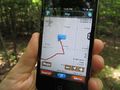
Todd's iPhone with the MotionX GPS app showing the coordinates (and part of the track) at the geohash.
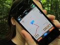
Phoebe avoiding the camera, but with a good picture of the coordinates again :)
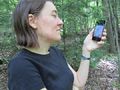
Phoebe caught without blocking her face.
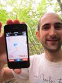
Todd with iPhone held towards camera. This would have been a better effect if the iPhone was in focus.
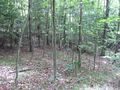
Boring trees at the geohash.
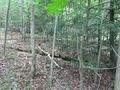
Boring trees at the geohash while looking uphill.
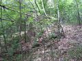
Boring trees at the geohash with a slightly less boring mossy rotting tree on the ground.
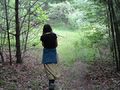
Leaving the successful geohash.


Achievements
Phoebe & Todd earned the Land geohash achievement
|