2012-06-10 53 4
| Sun 10 Jun 2012 in 53,4: 53.0537277, 4.7302875 geohashing.info google osm bing/os kml crox |
Location
In the dunes of Texel, really close to the 2012-06-04 hash.
Participants
- Mennoowh and
- girlfriend
Plans
Mennoowh was already planning to go to the/some beach on sunday. Texel is certainly an option and it will make up for some of the pain of the 2012-06-04 miss. Just have to convince my girlfriend to come along.
Mennoowh's Expedition
We left our home in the 52 5 graticule around 11h for a long trip. The weather prediction of Friday for today was not too good (90% chance of rain), so we didn't take sunscreen or hats or something. First we took the train straight to Den Helder. From the station we walked along a unfindable geocache that made us miss the boat by 1 minute. Luckily the boats go each half hour this season. From 't Horntje we rented bikes and slowly pedaled towards the beach first. There was a spectacular catamaran sailing race around the island happening at the time (which happened to be the world's biggest (600-ship!) catamaran boat-race [1]. Almost all of the catamarans unfolded their spinnaker right before our nose which was really cool to see as it made them go even faster. We sat on the beach for some time, saw lots of catamarans pass by really fast, threw some Frisbee, and left a mark in the sand for the internet's sake. As I was taking all the pictures with my phone with a nice reflecting screen, it was really hard to see what exactly I was photographing, which explains the partly missing D...
The weather was, unexpectedly, really good with lots of sun, lots of blue sky and no rain at all, so we burned our noses and necks. (Hrm I now paraphrase it as if we meant to do that, we didn't however)
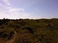
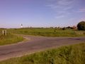
After some time we took up our bikes again and cycled north to try to meet my cousin (who lives on Texel and whom I tried to puppet-master to the 06-04-2012 hash). I say 'try', because we didn't succeed in meeting. This left just us two to go on through polders, woods and dunes. Really nice polders, woods and dunes at that. From a snackbar where we parked our bikes we walked along a path into the dunes. I wasn't really sure about how legal just walking into the dunes would be, but we didn't meet a fence or something, so we just walked on. There were quite a few thornbushes and brambles with nasty thorns, plus the thought that there might be many ticks, but it didn't prevent us from going on. The hashpoint was between two dune ridges with a nice view of dunes all around. Still having trouble with the sun on my phone screen, I took a bit unfocused photo of the GPS.
Then, after discussing possible achievements that we could get (Geoflash? Too many thorns. Formal attire? Don't have it) and have my girlfriend declare geohashers insane, we turned back to our bikes. Then again, through the woods and the polders. At Den Hoorn I was surprised to see a hill which probably formed in the before-last ice age (the Saalian). I later looked it up and the hill indeed contains till, which makes it a till hill. (Muahaha for Mad Science!) Even more entertaining: all over the south part of the island are beach poles which mark the coastline of different times. Right in the middle of Den Hoorn, on the steep southern side of the hill is one that says "floodline 1290". It stands in a street which is called Klif, which both surprised me and didn't surprise me after all... (you know, the feeling that says "Huh what? Oh yeah, of course...")
Well, enough earth-sciencey stuff now. On the way back I made a picture of a sheep, to support Murfie's theory that, really, everywhere are sheep. Then after a nice dinner in the sun at my cousin's place, we took the boat, bus and train home, where we discovered no ticks at all but lots of thorns in my socks.
So, no virgin achievement here, but I'll probably get another one sometime. :)
Photos
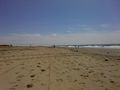
Catamaran boat race
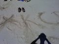
We're from the internet
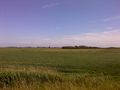
Texel polder
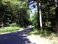
Texel woods
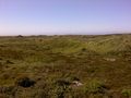
Texel dunes at the hashpoint
More Texel dunes
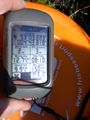
We reached it, yay!
Nice scenery with frisbee
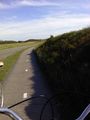
Biking back
Till hill at Den Hoorn
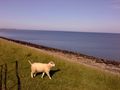
A sheep for Murfie
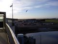
Taking the boat back


