2012-07-06 50 11
| Fri 6 Jul 2012 in 50,11: 50.9346288, 11.1178538 geohashing.info google osm bing/os kml crox |
Location
In a rather wet, bushy, gps-unfriendly forest
Participants
Plans
Planning? Me? Well, the spot lay next to the street leading to another Autobahn exit of Erfurt, so I thought it's not that much of a detour on my way home.
Expedition
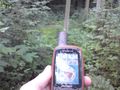
Found a small parking bay on the road just 400m from the hash coordinates. Crossing a meadow, I saw that it was possible avoiding entering the forest by going round its edges on the meadow further, so I had only 150m left when entering, finally. 30m on I realized two things. a) It had rained quite a lot in the last two days and b) a big forest with healthy tree crowns above and thick underbrush is quite a bad thing for GPS reception. So while I was getting wet from making my way through the underbrush, I was getting wet from sweating in 100% humidity... and the gps device completely misguided me on the first run, at some point deciding the coordinates were 46m behind me instead of 30m in front of me... When I reached the implied coordinates again, the signal wasn't "jumping" as badly, still, the hashdance led to nothing better than 3m. Since I had danced around half the forest already, I decided that was close enough and swam through the rest of the wood towards the meadow. There I was greeting by some very big mosquitos who were very interested in some sweaty, stinking (assumable) dinner, so I ran the rest of the way to the car and into safety. Success, after a long break. :)
Photos

Half grin 4m from the coordinates
Steep territory and wet underbrush. We are huge adventurers, conquering 100m of forest, eh?


Achievements
- Land