2012-08-25 34 -82
| Sat 25 Aug 2012 in 34,-82: 34.5604246, -82.3612976 geohashing.info google osm bing/os kml crox |

Location
Just north of Honea Path, SC. 30 minutes south of Greenville.
Participants
Plans
Hoping to start heading towards the geohash by noon. Probably arrive around 1:00pm or so. Rationalizer 09:05, 25 August 2012 (EDT)
Expedition
Decided to drag my girlfriend along for this geohashing expedition. We left around 12:40pm on the ~30 minute drive to the geohash location Via Google Maps, I had surveyed a nice dirt road that would lead to a small clearing that was about two-hundred yards from the hashpoint. When we arrived, however, we found that road was gated and fell back to plan B, a suitable parking area behind a small country church about 0.4 miles from the hashpoint. Although the woods were pretty thick in most areas, we were able to hike in pretty straight line for the first half of the hike. About halfway to the site, the woods opened up to several decent sized, man-made clearings complete with 2 deer stands (totally thought we were going to get shot getting in there) and several dirt roads similar to the one I had originally scouted for parking. This made for a much easier approach to the hashpoint as we were able to get within a couple hundred yards of the point. The last bit required some downhill navigation through a low area (would have been a swamp if it had rained in the past week) and within 15 or so feet of the point. The brush severely thickened at this point, however, barring access to the actual site so I snapped a picture and called this one completed.
Photos
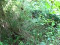
The actual site was up in there about 10ft

First Geohash success!

My beautiful partner that was willing to accompany me.
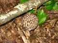
One of many interesting mushrooms we saw on the way
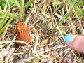
Lots of wildlife seen on our hike
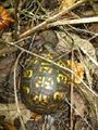
Another little friend we encountered


