2012-09-21 66 25
From Geohashing

| Fri 21 Sep 2012 in 66,25: 66.4302360, 25.7126409 geohashing.info google osm bing/os kml crox |
Contents
[hide]Location
About 10 km from my home as measured from the map, in Tavivaara.
Participants
Expedition
- By car total 20 km
- Walking total 0.4 km
- Expedition took 1 h
- Physical effort (1-5): 1
It has been very rainy days in Northern Finland. Today afternoon suddenly at 4 p.m I saw the sun shining momentarily and decided to hash. I drove about 10 km. The last 2 km was very narrow forest road, but I could still drive almost to the hashpoint. This was very easy hashpoint, it situated only some meters away from the forest road. Around the Hash there was young forest with small trees, so I could see the beautiful lake "Kursunkijärvi" from the Hash. Nice Hash!
Photos
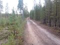
150 m to the Hash.

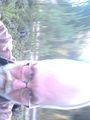
The Proof.
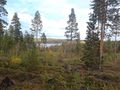
View from the Hash.
ETH aka ExtraTerrestial Hasher.
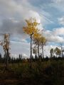
Autumn in the forest.
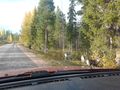
Reindeers on the way home.


Achievements
isopekka earned the Land geohash achievement
|
Geohashing Expeditions and Plans on This Day
Expeditions and Plans
| 2012-09-21 | ||
|---|---|---|
| Northam, Australia | Snaplatitude, a lady friend, a geologist from Western Austra | In a paddock in Mumberkine, Western Australia |
| Newport News, Virginia | Bob0the0mighty | at Randal's alma mater, CNU, and right in front of Gosnold Hall, the comput... |
| Sparta, Wisconsin | SwensonJ | Wooded area northeast of Fennimore, Wisconsin. SwensonJ is thinking about ... |
| Zürich, Switzerland | Calamus | A pathside out of Effretikon |
| Most, Czech Republic | Ravise | 350m in fields near Volevčice village |
| Frankfurt am Main, Germany | Yakamoz, Rincewind | On a field near Butzbach, Hessen. |
| Turku, Finland | nsk | I were cycling from Turku to Salo today and this seemed to be so easily acc... |
| Rovaniemi, Finland | isopekka | About 10 km from my home as measured from the map, in Tavivaara. |