2012-10-04 62 27
| Thu 4 Oct 2012 in 62,27: 62.8258864, 27.4022196 geohashing.info google osm bing/os kml crox |
Location
Rural area outside the town Kuopio, near house Airaksela. Should be easily accessible, almost directly on small forest trail at regular Finnish forest. The hashpoint is 12,7 km from my couch (as the crow flies).
Participants
Plans
I had to wait a mere 3 days from the day I decided I would start geohashing, and the geohash fell only 12,7 km (as the crow flies) from my couch!
This one will definitely be easy to reach, as there is a trail marked in the map almost directly on the hash. It's at least a forest trail, or even a road drivable by car. However, I'm going to try to reach it by bike. Although the hash may fall directly in the road, the Speed Racer achievement would not be possible without some sort of a rally car, as the road/trail is most likely very bumpy and narrow and the default speed limit on rural roads is 80 km/h. However, there is a small change that the owner of the private road I'm going to use to get to the hash (using private roads when travelling on foot or by bike is allowed in Finland, and in some cases even by car) will have posted some sort of speed limit to the road! In that case I'll hope it will be 30 km/h, so I have a chance of getting the Speed Racer achievement by bike!
Further plans: Maybe I should even try the Tron achievement, if there is a path drivable by bike leading through the woods from the hashpoint.
Expedition
After finishing work that day, I packed my stuff and hit the road with my trusty bicycle. It was a cloudy autumn day, still some colorful leaves on the trees painting the landscape. I started towards the hashpoint first on familiar roads, and only after a few kilometers ventured into unexplored territory. Although there were quite a few respectable hills, I was making good pace.

I tried to carefully check when I had to turn away from the main road to the smaller gravel road, but still managed to miss the turn by a kilometer. Dang! There goes my Tron achievement! Well, at least I now know that the road names given by Google Maps cannot be trusted, next time I will have to double check those using another map. I turned back and soon found the right intersection. GPS reading to the destination showed about 2 km now.
I rode through the village, which actually was just some houses scattered along the way, as we Finns like to arrange our housing. :) All the dogs were overjoyed by my arrival, as now they finally got something to bark at. Soon I was at the intersection and turned to an even smaller road towards the house Airaksela in the vicinity of which the hashpoint lay.

The road circled the house, as I had seen from the map, and then I already saw the beginning of the trail. To get there, I had to go through another houses yard, however there seemed to be nobody home and I thought I could go through without having to resort circling the house through the woods, which would look even more suspicious if someone was watching. The trail was definitely not passable by car at this time of year, because the bushes had overgrown the road quite a bit, but I could easily bike through, as the ground was hard-packed.
As I got nearer, I found out that the hashpoint was not on the trail, but about 8 meters to the side. There was a one meter deep ditch between, so I couldn't drive my bike all the way to the hashpoint, but had to drag it along the last few meters. And there I was! My first geohash! I was overjoyed, as you can see from the picture.
After snapping a few pictures for proof, I started the return trip. First I went ahead to see if the trail would continue somewhere, but had to turn back soon, the terrain definitely wasn't ridable with this bike. This would have thwarted the Tron achievement anyway, so no regrets for that anymore.
Otherwise the trip back to home was uneventful, but I started to feel a little saddle sore at the end. When I got home, I looked at distance traveled from my GPS, and was no longer surprised by the feeling. I had driven 38,1 km! Ok, because of the GPS jitter at the hash point the distance was actually a little less than that, but probably only 100 meters, since I have noticed before that the odometer in Garmin eTrex works surprisingly well, because there is a threshold how much movement is considered really moving.
This was a successful and fun first geohashing trip and gives a good starting point for my future geohashing ventures!
Photos

On the hashpoint with my hashcot.
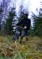
Proof I was there by bicycle.
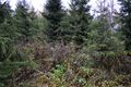
Landscape as seen from the hashpoint. Typical Finnish forest maximized for wood production. This section was cut down some ten years ago.
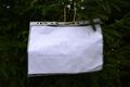
The note I left on the hashpoint for locals to wonder.


Achievements
Tilley earned the Graticule Unlocked Achievement
|
Tilley earned the Bicycle geohash achievement
|
Tilley earned the Land geohash achievement
|