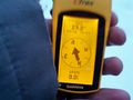
2012-12-20 61 23
| Thu 20 Dec 2012 in 61,23: 61.6308743, 23.5324032 geohashing.info google osm bing/os kml crox |
Location
Viljakkala, Ylöjärvi, near Särkijärvi.
Participants
Plans
National Survey topographic map shows some building near the hashpoint so it is likely to be on private property. But the road to the site is missing from OSM, so at the very least return with a GPS trace and add it to OSM for OpenStreetMap achievement. If the hash can be reached, the route could also barely qualify for Juggernaut achievement. We'll see...
Expedition
TeukkaM
Here's what happened. I started out from near my working location, setting my GPS to trace the route too see if this expedition could qualify for Juggernaut. After some minutes of driving I reached the intersection of the road passing the hashpoint. There were no tracks in the snow, except the barely visible snow-covered tracks of the plowing tractor. This was good news, as it was a sign that apparently no one lives here permanently and I wouldn't need to be answering any questions.
I decided to continue surveying on foot a) to get as precise trace as possible, b) to not look too suspicious c) to not get my car stuck in the snow. As I started to approach the hashpoint, I thought I heard the sound of a skiing pole from the lake. I stopped to look around and realised where the noise was coming from. Actually it was the sound of a large flock of long-tailed tits (Aegithalos caudatus). I tried to take some pictures of the birds but I probably won't win a nature photo prize with my cellphone pictures.
Next thing I saw were some awesome cliffs. Soon I started to see small cottages right next to the road. As the road was not marked as private, I know I could continue about my business. As long as I stayed on the road, the freedom to roam would be in effect. I got a somewhat uncanny feeling when a sensor light went on at some point, but pushed on. The road made a slight left turn and the plowed section ended there. There was a set of footprints in the deeper snow, but they too looked old enough that I wouldn't be barging on anyone's privacy.
After some really beautiful cliffs complete with ice falls, I finally reached the vicinity of the hashpoint. I could see that it was next to someone's cottage. Summer cottages are really popular targets for burglars this time of year, so I didn't want to upset anyone, much less set off any alarms. Good news was that the hashpoint was indeed visible from the road, qualifying the "line of sight" condition of the OpenStreetMap achievement. Thus, I proceeded to trace the road as long as it would go on before entering someone's private yard.
At the end of the road I turned back, took a photo of the closest possible point and scribbled the standard xkcd greeting in the snow, knowing that it would most likely be covered by new snowfall by the end of the day. This expedition was totally worth the trouble!
- Basically easily reachable from my work location. Could be private property though. -- TeukkaM 07:12, 20 December 2012 (EET)
Tracklog
Photos
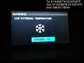
A bit nippy @61.6328,23.5201
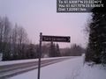
Proof of road name for OSM. @61.6217,23.5308
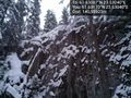
Some pretty impressive cliffs here @61.6317,23.5304
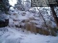
Even more impressive ice falls @61.6310,23.5335
Time to call it quits. This is as close as I'll dare. @61.6310,23.5325
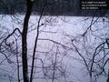
Dark blotches are birds @61.6326,23.5273


Achievements
TeukkaM earned the No trespassing consolation prize
|
TeukkaM earned the OpenStreetMap achievement
|
Is it true that User:Teukkam earned the Juggernaut?
|