2012-12-20 62 26
| Thu 20 Dec 2012 in 62,26: 62.6308743, 26.5324032 geohashing.info google osm bing/os kml crox |
Location
Near Rautalampi, in the peninsula Mäkäräniemi, in forest.
Participants
Plans
Second hashpoint of the double hash achievement. (First one.) A shorter detour by car, but possibly a longer walk, as the road is ploughed almost certainly not nearer than 500 meters from the hashpoint.
Expedition

As we drove towards Rautalampi, the sun went into clouds and some flakes of snow started to drift from the sky. Not many, though, as the temperature was still -18°C. We located the turn to the small gravel road leading to Mäkäräniemi easily. The name of the place means "Gnat peninsula" after the small biting insect, which common near swamps. Does not sound very nice place to have a summer cottage in. The next turn to the even smaller road was not easy, as the roads all looked the same, luckily I had saved the coordinates of the intersection to my GPS prior to trip. Soon we found ourselves in the second intersection, 500 meters from the hash. As I had anticipated, the road ahead, which led to two summer cottages by the lake, was unploughed, so we could continue no further by car.

I was still reluctant to take our mini-geohasher all the way to the hash, so she stayed in the car and my wife had to also leave there to keep her company. I took my sweater off so I could keep a faster pace without sweating too much and started trotting towards hash.

The small road had been ploughed at least once this winter, so there was only 15 cm of snow. I followed the road to a point where a forest machine track separated from the road towards the hash, at this point GPS read 150 meters to the hash. After 50 meters, the forest ended to a clearing, on the other side of which the hash was located. There was quite a nice view towards the lake from here (the photograph can't quite convey it), too bad the sun wasn't to be seen anymore.

In the clearing there was more snow, knee-deep. Luckily it was uncompacted, as the temperatures had been steadily very cold for a couple of weeks. The clearing was the product of the super-efficient Finnish forestry industry, where they nowadays rip even the stumps of the trees from the ground. I was having hard time keeping myself upright when walking through the holes left by the stumps, as the snow made it impossible to spot them.
But I found the hashpoint, which, unsurprisingly, was among the few years ago planted small trees about 20 meters from the edge of the clearing. So, again there wasn't any other view than snowy trees from the actual hashpoint. I wonder if anybody thinks I'll just go to my back yard forest to take these hash pictures, they all look so identical. :)
I waded back following my own tracks, and we sped to our way. These hash-visits made a nice adventure for a normally very routine trip!
Additional photos
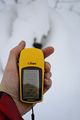
A better picture of the coordinates.

Achievements
Tilley earned the Graticule Unlocked Achievement
|
Tilley earned the Multihash Achievement
|
Tilley achieved level 2 of the Minesweeper Geohash achievement
|
Tilley earned the Frozen Geohash Achievement
|