2013-02-24 35 -79

| Sun 24 Feb 2013 in 35,-79: 35.7368110, -79.2121390 geohashing.info google osm bing/os kml crox |
Location
This hash appears to fall directly on eastbound Hwy 64.
Participants
Plans
Birdray will be driving just past this hashpoint on the westbound side, sometime probably in the late morning or early afternoon. I intend to turn around long enough to hit the hashpoint and maybe get the Speed Racer achievement!
I've realized that I don't have a camera with which to document both me and the coordinates, given that my phone serves as both my camera and my GPS unit. So, I'm venturing into tracklogs. I downloaded this app (GPS Logger for Android) and I'm going to give it a try. I'll also snap a picture of at least me, the date, and maybe the cell tower in the distance? We'll see. Hoping I don't earn the Police Achievement for this one.
Expedition
I was spending the weekend with family, and realized this particular hashpoint fell right on my way back home--except on the eastbound side of the highway instead of westbound. I was planning on heading by it on the westbound side, making a U-turn, and hitting the hashpoint that way.
I started up GPS Logger and crossed my fingers; I know better than to trust new tech to work perfectly the first time you use it, but I'd just downloaded it that day, so--oh well. I plugged the hashpoint into my phone's nav so I'd know when I was getting close (I've driven this route many times before) and headed on my way. Suddenly I realized I was being instructed to drive through Pittsboro, which wasn't my usual way. I figured the nav had figured out a faster way directly to the point, so I went with it. Then I realized, watching the map, that I was going to hit the hashpoint and make it to my destination without ever crossing my own path. Hey, there's an achievement for that, right? I was planning on doing the Speed Racer achievement, but this was so much cooler.
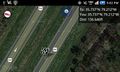
I let a lot of faster cars pass me, then started getting ready to pull off the highway about a tenth of a mile before the hashpoint. I slowed down quite a bit, but I was still surprised by how bumpy my landing on the grass median was even after I passed the rumble strip. I'm not sure I've ever had to pull off on the side of the highway before (especially not the median side)! When I stopped, my GPS said I was about 350 feet short of the point. I was pretty sure driving cheerily along the median until I hit the point was not a good idea. I pulled back onto the road (and kicked up a good bit of damp sod in the process--I could smell the grass inside the car), went a little further on, and pulled off again. Overshot by 90 feet! I took pictures anyway, figured my tracklog would show I hit the point, and went on my way.
About fifteen minutes later it occurred to me that the Tron achievement probably required one to return to the same point they left from, as opposed to traveling between two points, and that I hadn't gotten the Speed Racer achievement either. I sulked for a mile, then got over it.
Some time after that, my phone froze. I watched it for awhile, as sometimes the navigation causes it to hiccup--but no, it was a hard freeze. I hoped my tracklog survived. (It did. Mostly.)
It then occurred to me that I had left my own residence, traveled to my family's, hit the hashpoint, and was returning to my parking lot again without crossing my own path. Ha! Maybe that would count, I thought.
Tracklog
Here's my tracklog on EveryTrail. (I'm having a hard time getting it to load, but I'm hoping that's just my internet.) I'm realizing that, at least when I'm traveling by car, I should be dropping breadcrumbs more often, as the track isn't following the road. Here's my route as it actually happened.
Photos

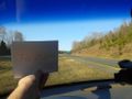
Me in my trusty car having stopped just past the hashpoint (with some wild refraction c/o my window I guess)
I was trying to get a shot of the exit sign for better proof of location, but it didn't come out clear enough
Pulled over just past the hashpoint


Achievements
Birdray earned the Land geohash achievement
|
Birdray achieved level 1 of the Minesweeper Geohash achievement
|