2013-03-09 51 -2
| Sat 9 Mar 2013 in 51,-2: 51.3306481, -2.6416891 geohashing.info google osm bing/os kml crox |
A nice cycle south of Bristol for my first geohash in this graticule
Location
Western edge of Chew Valley lake (opposite Herons Green Bay), along B3114 Chapel Lane.
Participants
Plans
Arranged quite last minute. Departing Bristol on bicycle around 2pm, with camera - ETA 4pm.
Expedition
Setting Out
After planning a bit of a bike ride (initially planned to explore South Bristol), I discovered the Saturday meetup was a mere 14 miles away - too good to miss. I moved to Bristol in October and hadn't managed a geohash in this graticle yet, today was to be the today!
Weather was fine (overcast but dry, not too chilly), and so I set out around 2.15pm. I headed into Bristol City Centre, and then out through Arno's Vale and toward Whitchurch. The route was aided throughout by National Cycle Network Route 3 - thank you Sustrans!
From Bristol south to Whitchurch was fine along the cycle route. At Whitchurch I turned south-west to head toward Chew Magna - the cycle route here utilised country roads (specifically Norton Lane) - a bit bumpy in places but still adequate. Upon arriving in Chew Magna I noted I was making good time. It was extremely tempting to stop for a drink - there's some lovely little shops and pubs there. I will definitely have to go back!
After the long (and relatively boring, slightly hilly) stretch between Whitchurch and Chew Magna, the route on to Chew Stoke on the B3114 went quickly. As I continued past Chew Stoke the lake loomed into view ahead to my left. Impressive!
I got out my GPS (a phone) and watched the 'distance' value decrease as I cycled along the path adjacent to the main road. It got to a minimum of less than 50m at a section where the lake comes right up to the roadside to the east (known as Herons Green Bay), and a small reservoir sits by the road on the western side. I chained up my bike, and headed across the road to the western side. 3.45pm - I had done it!
The precise hash location was within the boundaries of this small western reservoir. It was surrounded by a low barbed-wire fence, but I walked along to a padlocked gate which I was able to hop over (it was only waist height) - sorry Bristol Water! Heading back along to the hash and down the slope, I was extremely happy to see the distance marker of my GPS go green without my feet getting wet! I had made the hash, just by the edge of the waterside on this western reservoir, just a few metres down from the roadside! 4pm. Nobody else turned up though.
Returning
I took a few photos of the area and the lake, digested a few cereal bars and a glug of water, and then hopped back on my bike to head back to Bristol; it was getting a bit cold. As I passed through Chew Stoke, just a mile or two north of the hash, I paused as I'd seen a potential alternative route back - a bit of a variety. However, when I went to pedal off again, I had a flat front tyre. Oops.
I was wearing a cycle helmet and fluorescent ankle clips, had lights on my bike and a high-vis vest in my rucksack. I had phone, wallet, a bottle of water and snacks for the journey. However, I had not brought a pump or a puncture repair kit. Oops.
I set off walking. Google reckoned it would take me three hours to get home - I'd be back by 8pm. Not too bad. The local village store/garage was shut, no buses ran on a Saturday, so I didn't have much choice. I rang a friend who didn't answer, so off I toddled.
After about half a mile (again, taking a different route, since Google advised it would be quicker) a couple of cyclists wearing all the right kit stopped by me to check their map. I asked if they had a puncture repair kit and they kindly advised and helped me out. Whoever you guys are, from Weston, thanks for your help!
I set off back onto my outward route - familiar territory. Alas, in my haste and with dirty, numb hands I didn't make a proper job of the puncture repair. By Chew Magna the tyre was flat again. The local shop again looked shut. Only one thing for it - walkies!
I followed the cycle route back toward Whitchurch and then headed up the A37 Bristol road. Zigzagging through a few more streets, I got home by 8.45pm. Saw some parts of Bristol I'd never seen before, so that was nice. Pizza in the oven and a good night's sleep followed. A great adventure! 17.2 miles cycling, 10 miles walking, and one successful geohash - my first in this graticle.
Photos
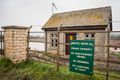
The only obstacle, to get from the road to the geohash.
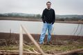
Me (aaronboardley) at the geohash.
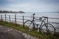
My bike after the 22km journey there!.


Achievements
aaronboardley earned the Land geohash achievement
|
aaronboardley earned the Bicycle geohash achievement
|