2013-03-13 42 -72
| Wed 13 Mar 2013 in 42,-72: 42.3036635, -72.5958939 geohashing.info google osm bing/os kml crox |
Location
Near a clearing in Skinner State Park, Hadley, Massachusetts.
Participants
Expedition
Todd and Phoebe drove from Florence to Skinner State Park. The gate was closed, so they parked in the lot and took the longer way in by trail. The trail was mostly clear of snow except a couple small stretches. It lead to within about a hundred feet of the geohash. There was a stream of water running over the leaves because it had recently rained. As they neared the point it seemed that it was going to be on the other side of a barbed wire fence. It probably was, but they were within an acceptable distance of about 30 feet (and likely also the accuracy range of the GPS), so they declared this a victory and sat down to a picnic of salad, vegetarian sushi, and miso soup.
Tracklog
Photos
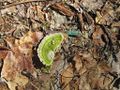
Colorful tree fungus found on the way there. Also wood rotting green. Weird.
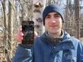
Todd holding the successful coordinates.
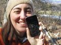
Phoebe very happy. And holding the successful coordinates.
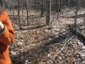
A temporary stream just barely visible falling over the leaves.

PPN (Proof of Paper Napkin) for the picnic achievement.
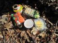
Our wonderful picnic, procured by Phoebe.


Achievements
Phoebe and Todd earned the Picnic achievement
|
Phoebe and Todd earned the Land geohash achievement
|