2013-03-30 44 -116
| Sat 30 Mar 2013 in 44,-116: 44.3109856, -116.0758843 geohashing.info google osm bing/os kml crox |
Location
In the hills near Smith's Ferry, ID.
Participants
- Eldin
- Pojana
Plans
The Payette Graticule looked likely to be reachable, so my wife and I decided to try for it.
Expedition
The expedition started out well. It was a beautiful sunny day, with warm weather, and the drive up towards the area with the hash was beautiful. The plan was to make a relatively quick stop at the hash, and then continue up to McCall, where my wife has never been before, to check out the shops, take in the scenery, and grab some food.
We found the turn off at Smith's Ferry without difficulty, and took the single-lane bridge across the river. The pavement ended about 500ft past the bridge, at a T-intersection. We turned left, since that road looked to be the most promising on the map. But were soon confronted with a 'Dead End' sign. Undaunted, as the map showed several roads that looped around through the hills to come near the hashpoint, we turned around and took the right road instead. We arrived at the first road that would have looped back towards the hash, it had a gate across it and a sign forbidding entry. The same with the second road.
We still weren't that worried, since those were just shorter routes across the bigger loop that the road we were on made. After a while, we started hitting patches of snow on the road (though the temperature out was over 50ºF). We made it across these without difficulty. Then, we hit the real snow. At first, everything was fine. But after making it around a bend I could see that this snow was going to go on for a long way, and get deeper soon.
So I stopped at what looked like a wide, relatively flat spot. And tried to turn around. This was where it all went wrong. My 'flat' spot, actually had a ditch beside the road, completely filled with snow. Soft snow. Unlike the dense, hard-packed snow of the road. About 16 inches deep. With mud underneath.
Upon hitting this ditch-snow, my front wheel immediately sunk to nearly it's radius in depth. Realizing my mistake, I tried to back out. But it was too late.
We got out of the car, and tried to dig out the snow around the stuck wheel. We tried putting sticks, pinecones, and floormats under the stuck wheel and various other wheels to get better traction. We tried to jack the car up so that we could put a larger log or branch under the stuck wheel. But the road-snow, though relatively dense and hard packed, could not support a substantial portion of the car's weight on the jack's ~10in² base.
After trying for over an hour to get the car unstuck by ourselves, we realized needed professional help. So we called around and found a tow truck that was available to come and pull us out of the ditch. It took about 45 minutes for the tow truck to arrive, and another 20 for them to get us out. In the end, no real damage was done, though it cost us $245 for the tow truck.
And the snowed over road appeared to be the only route to the hash which did not require crossing private property. We lost enough time to the 'getting stuck' incident that we ended up scrapping the plans to go all the way up to McCall, but we did continue on to Cascade, where we found a gas station/convenience store/sandwich&burrito resturant called Harpo's, where we got cleaned up and bought food and beverages. We then went down to the shore of Cascade Lake, which is still mostly iced over at this time of year, and took some pictures of the scenery and hung out in a park-like area we found before heading back home.
All in all, it was an enjoyable trip. But not enjoyable enough to be worth what it ended up costing us.
- Stuck in snow about a mile from the hash. Waiting on tow truck. Going to be an expensive failed hash. -- Eldin (talk) @44.3075,-116.0542 15:29, 30 March 2013 (MDT)
Photos
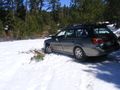
My car, stuck in the snow.
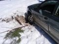
The results of our failed attempts to get unstuck.
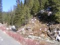
Across the river from the hash. We're actually closer here than we were where we got stuck, but on the wrong side of the river and at the bottom of the canyon. This photo shows terrain typical of Idaho graticules north of 43N


Achievements
Eldin & Pojana earned the Done with Nature consolation prize
|