2013-04-06 35 -92
| Sat 6 Apr 2013 in Conway: 35.0624746, -92.7345597 geohashing.info google osm bing/os kml crox |
Contents
[hide]Location
Near Petit Jean and Morrilton, on the shoulder of a highway.
Participants
Expedition
The drive to the spot was uneventful, though finding a place to leave the car was not, as stopping on the narrow shoulder of a highway to get out and take pictures is generally frowned upon. We ended up pulling up to a gate on the nearby Bone Hollow Road (Arkansas does have a knack for unusual road names!) and parking the car there, then walking back to the highway shoulder.
The shoulder itself was filled with rocks, and a ditch next to it was filled with rainwater. We crossed over the newly-made brook at the proper time, then used the GPS to track our closest approach. There was a fence covered with overgrown plants, but we didn't think it was on the other side... except that my GPS said it was. The weirdest part was that, while my GPS kept updating the west/east data, it never updated the north/south position once we got in the general area, though we undoubtedly moved at least the few feet necessary for a digit change.
Upon re-examining Google Maps, the point appears to be roughly in the ditch, not far enough away to be on the other side of the fence... but Google Maps can be faulty, and the fence is barely visible in the first place on their pictures.
Upon reflection, I think I'm going to trust Google Maps (both Street and otherwise) on this one, as both seem to show somewhat clearly that the point is on the other side of the fence, possibly even on the other side of the ditch. My GPS certainly isn't the most trustworthy, and even what it said was roughly 16 feet from the hashpoint, which is probably within margin of error.
Pictures
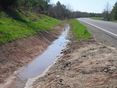
Ditch stream
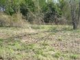
Hashpoint area
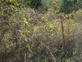
Hashfence
Closest approach

AshtaraSilunar

Haberdasher


