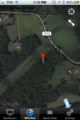
2013-04-07 40 -77
| Sun 7 Apr 2013 in 40,-77: 40.5354031, -77.1080671 geohashing.info google osm bing/os kml crox |
Contents
[hide]Location
This hash landed west of Millersburg near some HV power lines in farming country.
Participants
Expedition
After learning this Sundays hash point on Friday, we made plans to go visit the one in our graticule (40,-76). This morning, I discovered that the hash point the in the graticule just west of us was closer by around 10 miles, as well as being easier to access. Because of this ease of access, we decided to take the friendliest of the family dogs.
The drive was a familiar one, we go this way to visit family semi-regularly, and we talked about music, LSD, and Steven King books.
The problems started after we turned off I-322 and proceeded to miss a turn due to poor GPS reception and then drive by the hash point twice.
After parking near the some HV lines, we followed the path they cut through the woods. After about 8 minutes of GPS dancing, we found the point, took pictures, and left. All and all uneventful.
That's when I noticed a tick on my pants, after tossing it out the window we started checking for more. There was one on everyone, and two on the car.
Pictures
Looks like a good place to hash.
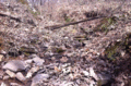
Nice stream running near the hash point.
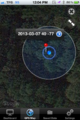
Point=Hashed


See the rest/high-res on THIS Imgur album.
Achievements
namAehT earned the Drag-along achievement
|
namAehT earned the Land geohash achievement
|