2013-04-11 62 27
| Thu 11 Apr 2013 in 62,27: 62.7650559, 27.7002228 geohashing.info google osm bing/os kml crox |
Location
In Kuopio, Kuhastenniemi peninsula, in forest.
Participants
- Tilley
- Tilley's daughter
Plans
This general area about 15 km south from where I live seems to get a lot of hashpoints. Before I've visited one point and a few has slipped by, but now I had time to do another. The point should be easily accessible, as the small gravel road that goes past the hash at a distance of about 30 meters, has several houses/summer cottages along it, so it should be maintained (roads that have not been ploughed whole winter still have about 30-40 cm of snow on top of them). ((Nice that the summer is soon coming and I don't have to worry about whether a road is ploughed or not, which seems to fill my pre-hash planning sections pretty extensively..)
Expedition
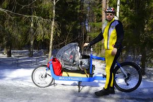
I had gathered the equipment on the evening before, so I grabbed them and packed my baby daughter to her crib. It was a very beautiful morning, temperature still a couple of degrees on the negative side. I was a bit worried about the air quality, as Kuopio is this time of year regularly the Finnish city with the poorest quality of air. This is mostly due to the vast amounts of sand that has been spread to streets during the winter and reduced to dust under the tires of the cars, and which was now blowing around by the same traffic. Fortunately I would be mostly taking smaller side streets and roads, which have not that much traffic. Nevertheless I shielded the baby from the dust as best as I could, with the plastic rain cover covering most of the crib and a piece of cloth the rest.
I sped along. The route was familiar to me from the previous hash-visit, the bicycle paths were finally free from ice (but not from sand) and I was making good pace, almost 22 km/h on average. The dust was not as ubiquitous as I had feared. The weather was perfect and this part of rural Kuopio is very beautiful with large fields, occasional forests, and in some points even glimpses of the lake Kallavesi.
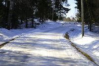
I found the right turn to smaller gravel road Niemeläntie easily, and continued along. The road winded along right between older houses and newer log-cottages, and in one point crossed a very narrow land bridge. On the left side there was a small bay well into its way turning into a marshland, on the right side a bigger bay. The final turn to Haukiniementie, and - it was in good condition. Phew. Only 400 meters to go. This even narrower gravel road was in parts, where it crawled along patches of forest, quite icy, and it was good still to have the studded tire in front. The hashpoint was quickly located, and I noticed it was 25 meters from road.
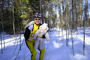
Unlike previous hash-visit the baby had awakened when I turned to the gravel road, and I freed her from her crib. Then I proceeded towards the hashpoint with GPS and camera in one hand and the baby in another. Trudging in the snow again, this time only about 30 cm of it. Right on the shoulder of the road the surface of the snow had been promisingly hard, supporting my weight, but of course between the trees there was no such luxury; the Sun doesn't melt the surface during the day enough for the night frost to form a thick enough crust layer.
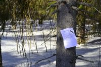
The hashpoint was nevertheless reached and some pictures taken. Then back to the road to get the snow out of my biking shoes. After a bit of a break, during which I drank some water, ate a banana, and the baby looked around, we packed our caravan for the return journey. I even remembered to post my prepared "Internet was here"-poster to a nearby tree before leaving. The trip home was uneventful. The baby, having rested at the hashpoint, had energy to sleep the whole way. My energy held well, and average speed for the whole 31 km round trip was 19.6 km/h.
Additional photos
Achievements
Tilley earned the Bicycle geohash achievement
|


