2013-04-29 62 27
| Mon 29 Apr 2013 in 62,27: 62.7354779, 27.7187222 geohashing.info google osm bing/os kml crox |
Location
In Kuopio, near Puutossalmi strait.
Participants
- Tilley
- Tilley's daughter
Plans
I can start this planning section by quoting my last expedition:"This general area about 15 km south from where I live seems to get a lot of hashpoints. Before I've visited one point and a few has slipped by, but now I had time to do another."
However, this time I'm not sure if I can get to the hashpoint, because if lies awfully near someone's house. When looking from Google street view, the hashpoint seems to be outside the fence surrounding the house, but the syncing to coordinates is sometimes a bit off in their map. The usually more accurate National Land Survey's map doesn't help either, because the fence is not visible there. The only way to be sure is to go there. I think I'll give it a go, it'll make nice cycling trip in any case.
Expedition

This was going to be my longest cycling trip yet with my daughter. Although my average speed on our cargobike has been improving constantly during the spring, the day was quite windy, and I was afraid how big of an effect that would have. The wind speed was averaging 6-8 m/s and it was blowing from south, so on the way there I would have constant headwind.
I carefully prepared. Most important preparation was keeping the baby awake as long as possible, to gather some sleep-debt. :) Then, after a quick fill-up from the mothership, I packed her along. After setting off, she fell asleep within 3 minutes, as usual. I wonder if she has doubts whether we actually go anywhere ever, as all she ever sees from our trips is the same couple of kilometers, which puts us barely past the local mall, and when she wakes, we are back home again.
The headwind was strong, and sometimes my speed dropped to about 17 km/h, although I was pushing as hard as possible. The journey was nevertheless steadily advancing, and the baby was in deep sleep. The route was thoroughly familiar because of the earlier hashtrips to same direction. There were several open fields in way, so I didn't even have the luxury of forest shielding me from the wind in the stretches, where the road was not going directly to south.

At last I was on a point where I started to cover some new ground. I turned my GPS device to show the distance to the hash. 5 km to go. My excitement started to rise. Then only 1 km. 500 meters. Now I could probably see the house I was headed to, near the main road. Approaching the intersection, I still had no way of knowing if I could get to the point. Then I turned from the main road, and: disappointment. The point definitely was inside the fence. I could now also see, why there is a fence: there were three small dogs inside. The dogs hadn't noticed me, because I had approached from downwind. As I parked near the gate to ponder the situation, I managed to clang my cycle stand so loud, that the dogs came running towards me and started barking. I quickly decided to retreat. I didn't want to immerse myself in a lengthy conversation with the house folks about how it is absolutely necessary for me to walk 10 meters into their yard to take a picture of my GPS device. Especially when the dogs were constantly barking and the baby was already beginning to stir from the noise, and we probably were a strange-looking party, with the loaded bicycle and me wearing couldn't-be-farther-from-formal-attire gear (bicycle shorts and on top of them technical underwear bottoms, because I don't own thigh-type cycling trousers, and it was too hot for the skiing outfit I have earlier worn on expeditions, and too cold (about 10 °C) to wear the bicycle shorts by themselves).

I retreated back to the intersection, about 40 meters from hash, and luckily the dogs were well trained, they stopped barking. I then took a couple of pictures for the report, drank some water and home made mead, and started my journey back home. I didn't let my first failure affect my mood, as now I was looking forward to riding 17 km with tailwind. In Finnish we have a saying "A hill always pays its debt", meaning that after an uphill there is always a downhill. The same seems to apply for a wind, at least with this bike, probably because of the unaerodynamic structure. On level road and the strong tailwind blowing I occasionally recorded 35-37 km/h speeds. On the return trip my average speed was over 25 km/h, because the whole trip average was 22,6 km/h, and on the way there it was about 20 km/h (I didn't remember to look at the hashpoint what it precisely was). The whole trip was 34,5 km, and a nice cycling trip it was, although the hashing part wasn't successful this time. The baby slept the whole time and awakened when I parked the bike. :)
Additional photos
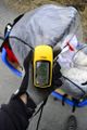
A proof I was near the hashpoint. :)

Achievements
Tilley earned the No trespassing consolation prize
|