2013-05-04 47 9
| Sat 4 May 2013 in 47,9: 47.0831226, 9.5235966 geohashing.info google osm bing/os kml crox |
Contents
Location
The geohash is on a meadow between Balzers and Triesen (Principality of Liechtenstein).
Who Went
TheOneRing - by public transport.
The Expedition
TheOneRing
Well, again a must have I think. The Principality of Liechtenstein is not very large and lies completely in the graticule of St. Gallen. Furthermore, the country contains parts of the Alps. You see, the probability that a geohash can be reached might be very small. Today, this was the case and the weather was better than forecastet. So, no excuses.
I went by train to Trübbach via Zürich and Sargans. Trübbach is a village on the river Rhein and directly on the opposite side, there is Liechtenstein. I didn't walk through Balzers but on a bypass road around it. The distance from the train station was about 3.5km as the bird flies and the total way was not much longer, just about 4.5km.
I left a forest road way too early and walked over a first meadow. So what, you may ask, but in the last days it rained a lot. Shoes and socks got wet in no time. When I approached the geohash, I saw another forest raod which I also could have taken. Living is learning, I guess.
At the geohash, I took the usual photographs, not only from me but also from sheer rock walls right next to the geohash. Maybe 1km or even less to the West, and the geohash would have been impossible to reach. Sometimes the odds are in your favour.
On my way back to Balzers, I walked into a shop and bought a new pair of socks, to get dry feet. Although I brought a spare shirt, I didn't bring socks. With dry feet, I walked through Balzers and took some more photos. I wasn't able to find a restaurant to have lunch so I walked back to Trübbach and reached the train station when the train approached.
Great trip, there is nothing more to add.
Photos
TheOneRing
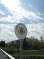
Welcome to Liechtenstein
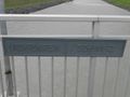
The border line
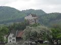
Gutenberg Castle in Balzers
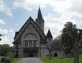
Curch in Balzers, built to honor John II., Prince of Liechtenstein
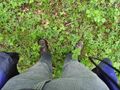
The geohash (not visible: wet socks)
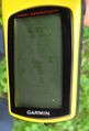
Coordinates reached
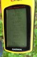
Some more information

The happy hasher
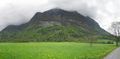
Sheer rock walls


Achievements
TheOneRing earned the Land geohash achievement
|
TheOneRing earned the Public transport geohash achievement
|
TheOneRing earned the Border geohash achievement
|
TheOneRing achieved level 3 of the Minesweeper Geohash achievement
|
TheOneRing achieved level 5 of the Minesweeper Geohash achievement
|
TheOneRing achieved level 6 of the Minesweeper Geohash achievement
|