2013-05-06
From Geohashing
Expedition Archives from May 2013
Sunday 5 May 2013 | Monday 6 May 2013 | Tuesday 7 May 2013
See also: Category:Meetup on 2013-05-06
Coordinates
West of -30°: .0662678, .7600527
East of -30°: .0051680, .9249640
Globalhash:
-89.069753974716,152.987033890720
Photo Gallery

Expeditions and Plans
| 2013-05-06 | ||
|---|---|---|
| Borrego Springs, California | LucasBrown | About 40 meters due east of the intersection of Tangle Foot Trail with CA S... |
| Rochester, New York | Hic Sunt Laganum | Scouting for points, a backyard adventure |
| Besançon, France | Crox | "Verger au Renard", near Route de Chaumont, Neuchâtel, Switzerland |
| Goslar, Germany | Mampfred | On a field near Schaderode. |
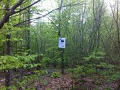
| Jämsä, Finland | Pastori, The Wife | In Nastola. The point lies near a road in a forest, the nearest feature wit... |