2013-05-12 54 -2

| Sun 12 May 2013 in 54,-2: 54.6778850, -2.0141189 geohashing.info google osm bing/os kml crox |
Location
Heather moorland just off a rural road at the top of the ridge separating the Wear and Tees valleys, County Durham, UK.
Participants
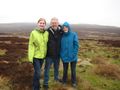
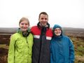
- George McBane Mcbaneg
- Jake Muonio
- Katja McBane
- Rebekah McBane
Expedition
Two hashpoints in a row in the Durham Dales (my favorite bit of country here in NE England): yesterday in a creek valley, today on a high ridge, and both within less than an hours' drive. So we figured, consecutive hash time.
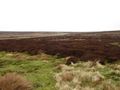
Today's hashpoint was only about forty feet off the road. Again, no GPS, and no useful smartphone location marker. But we had an easy time finding the characteristic triangle-shaped section of vegetation (dark green moss, as it turns out) that showed up clearly on the satellite map. The hashpoint surroundings were spectacular heather moor (as we expected from the location) but the visibility was so-so and the wind and light rain encouraged us not to linger too long. On some days the views into Teesdale and over to Monk's Moor would be stellar, but not today!
Photos
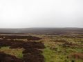
Looking W back toward road from hashpoint.
At the hashpoint, camera facing west.
Katja, Jake, Rebekah.
At the hashpoint, camera facing NNW back along road to Frosterley.
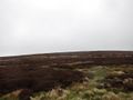
Camera facing east along ridge.


Achievements
George, Katja, and Rebekah McBane earned the Consecutive geohash achievement
|
George, Katja, and Rebekah McBane earned the Land geohash achievement
|