2013-05-16 46 -120
| Thu 16 May 2013 in Yakima: 46.4460994, -120.5228368 geohashing.info google osm bing/os kml crox |
Location
In a field west of Wapato.
Participants
Plans
I will drive from Seattle and arrive between 2 and 3. I'll also explore the Reservation Memorial Park, a little further down the road. This is my third attempt at the Yakima graticule, and I am hoping to achieve my 98th overall success today.
Expedition
- Stopping for supplies - then on to the geohash. -- Thomcat (talk) @47.6910,-122.3659 10:48, 16 May 2013 (PDT)
A nice cloudy day in Seattle - what better thing to do than drive 170 miles for a geohash!
No problem with the drive; the Prius managed the four passes just fine. Stopped at Miner's for a shake, and then on to the geohash.
- On pace for 2:45 arrival. -- Thomcat (talk) @46.5634,-120.4799 14:19, 16 May 2013 (PDT)
Easily found the field in question, and snapped a few photos before entering. Rows of young corn crops, a little less than a meter apart, are growing well. I stepped over the various rows to reach the spot. The geohash dance is a little stilted when you have to hop over rows.
The one problem I had was uploading to the net - though I seemed to have a cell connection, the upload took for-ever!
After the geohash, I headed down the road to the Yakama reservation memorial park. In the cemetery, geohash droid managed to upload the photo, but didn't complete the edit to the page :( Ah well. Geohash complete, I headed further east to meet my pal to see Star Trek 3D.
Photos
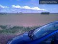
Young crops, a beautiful day near Yakama @46.4462,-120.5230

On the spot! @46.4461,-120.5228
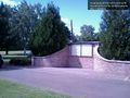
Reservation memorial park


