2013-05-19 39 -76
| Sun 19 May 2013 in 39,-76: 39.1036379, -76.6840838 geohashing.info google osm bing/os kml crox |
Location
In a swampy thicket of trees next to the Annapolis Area Christian School in Odenton, MD
Participants
- Allison
Plans
We were actually going to attempt this one on Friday because we didn't think we'd have time on Sunday. We set out at about 3pm but the time estimate from Google Nav went from 46 mins to 58 mins to 1h 30m before we even went a block so we aborted.
On Sunday we had a few free hours and decided to go for it.
Little did we know...
Expedition
Here are some messages posted from the Droid App, saved here for posterity/history.
- Heading there now. -- OfficeLinebacker (talk) @39.0931,-77.1554 14:47, 17 May 2013 (EDT)
- Heading there now -- OfficeLinebacker (talk) @39.0931,-77.1554 12:12, 19 May 2013 (EDT)
- Whose idea was it to go to this geohash anyway this the dumbest activity ever -- OfficeLinebacker (talk) @39.1025,-76.6875 13:57, 19 May 2013 (EDT)
++++++++++++++++++++++++++++++++++++++++++++++++++++++++
This was by far the most difficult and dangerous geohash I've done to date. Allison and I decided to go for it as it was in a forest only about 400ft from a road. Easy peasy, right?
So we get there and pull over, and the parking on the shoulder is a bit iffy, so we parked in the parking lot of the Christian School. The approach from the road would have been about 450 ft through very dense vegetation. The approach from the parking lot was about 500 ft but it was much safer to park there.
It had been raining earlier so we expected to get a little wet from wet leaves. There was no obvious entry point so we just charged in. The first 50 feet or so was almost pure thorny vines, but we got through OK and not too wet. We ventured through the densest growth I've ever traversed for a geohash. We had to go around thick brambles and step through some spongy earth. We crossed a path for walking and came to some much spongier ground. About 120 feet from the hash, Allison announced that geohashing is the stupidest activity ever, said she never wants to go geohashing again, and decided to turn back. I fought on.
I was having problems with the App zooming out and not staying on the default setting of recentering to keep both present location and hash on the same screen. It would zoom out so even though I was within 100 feet of the hash, the screen displayed the whole neighborhood. Maybe it was because drops of water got onto the screen? Also, the app/GPS would periodically pick up a spot about 3000 feet away which was frustrating. As I got closer, there was serious swampy land and I crossed three swampy areas on fallen trees. Well, two and a half. I got to a bit of a solid spot and the GPS was indicating that the hash was about 57 feet toward the road. Between myself and the apparent location of the hash was the widest, swampiest terrain yet, with a couple of ways to cross--a thin, solid tree trunk and a thicker, but well rotted one. Not wanting to make that crossing any more than I had to, I called out to Allison that I'd be coming out of the woods at the road and would walk back around. Generally speaking, I have good balance and love crossing streams and gullies on these natural bridges. I set across, and well, I guess I finally pushed my luck too far because after a few comical, arm-windmilling jerks, I had to step off the bridge into ankle deep muck. I was surprised at how cold it was. Once I got to the other side of the swampiness, the GPS indicated that the hash was...about 55 feet away...back in the direction I had just come from.
FUUUUUUUUUUUUUUUUUUUUUUUUUUUUUUU-!!!!!!
All of a sudden, the fact that I had only had a cup of coffee for breakfast and was hungry and had low blood sugar, and the fact that I get irritable when I drink caffeine, all caught up with me. I was acutely aware of how sweaty I was in the muggy humidity, every cobweb I touched got in my face, my boots were slippery, the stickers stuck with that much more alacrity, and ALL THESE STUPID BRANCHES. So I crossed back to where I came from and about 10 feet to the South was where the hash was. I uploaded a bunch of pics, and Allison texted me asking if I was OK. I called her and let her know I was on my way out and she gave me some tips about following that path we'd found. I hightailed it out of there, and when I got to the path it was so relieving and relaxing to not have to fight to take steps. When I emerged I found myself somehow agreeing with Allison's earlier characterization of our expedition (as least verbally and for humor value--I knew in my heart of hearts we'd do it again).
My boots and the bottom of my jeans were soaked, I was sweaty and covered in cobwebs, and I was irritated. But we were safe. AND we'd accomplished our goal.
I am giving myself the "Mother Nature is my Bitch" achievement for this one because, dammit, I deserve it.
Tracklog
Photos
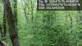
Very dense vegetation @39.1045,-76.6837
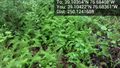
Ferns @39.1042,-76.6836
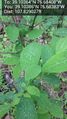
Water on leaves @39.1039,-76.6838

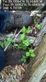
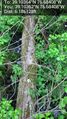
Mad at nature @39.1036,-76.6841
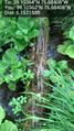
Because I fell in the mud @39.1036,-76.6841
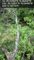
This is the tree branch bridge I fell off of. @39.1036,-76.6841
Another bridge I crossed. @39.1036,-76.6841
More natural bridges across the swamp @39.1036,-76.6841
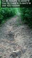
The path back to comfort and safety I hope @39.1047,-76.6848
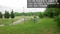
Free at last of nature's cruel mockery. I can't believe this nice area is only a few hundred feet from the hellhole swamp. @39.1050,-76.6844


Achievements
OfficeLinebacker earned the One with Nature Geohash Achievement
|