2013-06-09 62 27
| Sun 9 Jun 2013 in 62,27: 62.9011439, 27.7087961 geohashing.info google osm bing/os kml crox |
Location
In Männistö, Kuopio.
Participants
- Tilley
- Mrs. Tilley
- Tilley's daughter
Plans
We had been planning a one-night bike trip around the eastern part of lake Kallavesi this weekend. When the hashpoints for the weekend came into being, the time and direction to take that tour was clear: By starting northwards and beginning Sunday, we could log two hashpoints along the way, with only minimal detours on both points!
This first one presented some excitement, though. When I first looked the hashpoint from the Karttapaikka map, where you can see all the houses, too, I was disappointed: the hash was directly in a one. But when I looked from Google street view to see what kind of house that was, I was delighted: the house had no ground floor but was standing in kind of pillars and there was parking space at ground level. The hashpoint could still be reachable, if it was not on one of the pillars holding the staircases.
Expedition

This was our first overnight camping journey with the baby, so the packing took some time. After lunch, we were ready and left - directly into rain. Our gear was well suited for even rainy conditions and the weather was alltogether warm, so we just continued. The baby was having a little bit of hard time, probably stomach cramps. During the first few kilometers we had to fiddle with the packing a couple of times, then got it nice and steady.

The route towards the city centre of Kuopio was thorougly familiar for us. After 10 km of riding, the hashsite at the city district of Männistö a couple of kilometers northwards from the centre, was quickly reached. Nearing the precise house brought some excitement: what was the exact placement of the point? When we reached the house we even saw there was some construction work being done on the house, there were some ditches around it. These didn't luckily prevent getting under the house. And there it was! The hashpoint was not under any pillar, but neatly on an open space. About 3 meters under the house. We exited the bikes and the baby had already calmed down.

Getting a good reading with the GPS seemed a bit difficult first. The GPS updated slowly, and the first time I walked too far under the house, which made the GPS naturally to lose the signal almost completely. With another try starting under the open sky I managed to get sub-1 meter readings at the point for a few seconds. I am pretty sure I was there. As the point was straight below a housing section of the house, there were at least three potential couch potato earners! I forgot to bring my hashmark-papers with me, so I couldn't hint these Gladstone Ganders what they were missing.
After the necessary pictures - we didn't leave but took a longer rest stop under the house and rummaged our packs for some snacks for all of us. Mango and plum puree for the baby and some bananas for the adults. While resting, a small rain shower went by. Then we were ready to continue.

Rest of the day presented us some nice views from a brand new bridge, plenty of sun, the baby sleeping 2 hours straight (which meant mom and dad rode 2 hours straight), and then settling on a shelter of a lean-to in a beautiful swimming beach. Evening swim felt nice after 45 km of biking. (I know, it doesn't sound much for you road bike hashers, or recumbent riders in planes of Netherlands, but try to do it with this kind of gear. I don't know where I could weigh my bike but it probably weighed 60-70 kgs. We averaged 17 km/h.)
The next day and another hash..
Additional photos
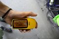
A picture of the coordinates.
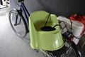
Always bring a potty to hashing trips - at least if youngest hasher in your team is 0,5 years old!
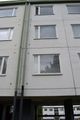
Here lives some potential couch potato earners.


Achievements
Tilley earned the Bicycle geohash achievement
|