2013-06-18 52 -1
| Tue 18 Jun 2013 in 52,-1: 52.6839444, -1.3229896 geohashing.info google osm bing/os kml crox |
Location
A field just south of Stanton under Bardon, Leicestershire, UK. Looks like it has public access, so we will find out.
Participants
- Nick Holden
- Pplspitbull
Plans
Looks like there is public access to the field with the hash, and my colleague Pplspitbull rides nearby on her way home. There are footpaths to three corners of the field, at least. With luck, we should be able to cycle in one way, out another, and then I will get home without coming back past work, to secure the tron achievement. Also a dragalong if I can persuade Pplspitbull to stick with me all the way.
Expedition
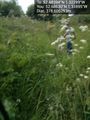
So, Ha! to the 'public access' bit. And Ha! to the idea that the geohash was in a field. The land was kind of in a field, except it was a field that had been planted as part of the National Forest, so it was basically full of saplings about eight to ten feet tall, and lots - and lots - of weeds, thistles, nettles, brambles, hawthorn, dog roses and wild grasses. Google maps made it looked like a ploughed field, but I guess that was a few years ago now...
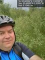
I had such high hopes. Rode to work as normal this morning, but deliberately stayed on the east side of our road, thinking (damn my over-confidence) that maybe I could notch the tron achievement into the bargain. Pplspitbull agreed to be my guide for the ride, given how close the hashpoint was to her normal cycle commute, so by the time we left I'm thinking drag-along as well as tron. See the over-confidence? Comfortable enough ride to the general area, about 500m from the hashpoint, and there should have been at least a footpath or bridleway. There was, kind of, but a random yellow tipped fence post sticking up out of a mass of six foot high nettles and thistles isn't actually very enticing. Pplspitbull said, helpfully, "look, there's a stile" so of course we climbed over, with the bikes, to get a better look. Maybe they're waiting for the forest to grow and then they'll re-open the footpath, but right now, the words that spring to mind are 'impenetrable' and 'impassable'. Faced with the prospect of having to admit defeat, we compromised: she, like a first-rate Sherpa, stayed behind with the bikes having guided me to within half a mile of my destination, and I did the last bit on my own to take the big stupid grin photo, and claim all the credit for myself. Seriously, it was Edmund Hillary and Tenzig Norgay but with less fur.
Not that the last bit was a cakewalk. The 'footpath' was designated a 'permissive bridleway', which apparently means you'd have to be stupid to ride a horse along it, but if you are stupid, they'll let you. In cycling shorts and ankle socks I pushed my way through nettles and other uncooperative flora round the edge of the soon-to-be-forest and plunged into the trees at a likely spot. No mobile signal, no WiFi (obviously), precious little battery left, and the GPS decided to play silly buggers, bouncing me around always 15 metres from the hash. Eventually, the spiral I was walking ran out of options, and I was able to snap a few photos within the requisite handful of metres, and then realise I'd walked in such a peculiar spiral I didn't actually know which way the path was. Hard to believe you can get completely lost in what used to be a single arable field a couple of years ago. Following some power lines led me back out to the perimeter path more or less in one piece and I stumbled back through the briars and nettles to where the newly-designated Pplssherpa was waiting. Oddly, after that she cycled straight home, and I'm not convinced I'm going to be able to persuade her to try geohashing again...
The ride home was somewhat extravagant, and I kept waiting for my ankles to stop stinging. It's five hours later, now, and they're still throbbing. The gentle buzz of geohashing, I believe they call it. Apparently nettle stings relieve pain in the limbs, but I didn't have pain in my limbs before today's adventure, so something isn't right there.
Still, a decent trek, a nice day out, pretty countryside and, dammit, I made it to the hashpoint. That's what counts, in the end. No tron, no drag-along, just a plain and simple land hash, 50km on the bike and some random wandering round in circles in a forest. A normal hash, in other words.
Tracklog
http://app.strava.com/activities/61250898 - doesn't include the ride to work, cos, well, boring!
Photos
This was pretty much where we decided we needed a new plan
Grin, and a baby forest
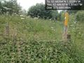
My collection of photos of "footpaths and cycle paths that really aren't" is coming on nicely


Achievements
- Land Geohash