2013-06-23 -37 144
| Sun 23 Jun 2013 in -37,144: -37.7840435, 144.9946319 geohashing.info google osm bing/os kml crox |
Location
On the banks of the Merri Creek, next to the Merri Creek Trail, Fitzroy North.
Participants
Five separate expeditions (in order):
- Tom W, around 2.30pm
- John and Cam, around 3.30pm
- Felix, around 4:30pm
- Steve, around 10pm.
- Tom A, Lachie and Miriam, around 11:30pm
Plans
Various emails were sent amongst us trying find a time for Tom W, Cam, Steve, Felix and Lachlan to meet up but we couldn't find a time that worked for everyone.
Expeditions
Tom W
Tom got to the hash first, on foot via a long walk from Kew to Coburg. Other exciting things probably happened to him too. Got a slurpee within 2km.
John
Late the night before I noticed how conveniently located this day's hash was. I even considered hopping on my bike right then and there since it would be after midnight by the time I got there. I didn't do that however. So at about 2.30 (afternoon now) I headed off from home, looking forward to the ride which was made up almost entirely of bikepath. Riding through Royal Park I was struck by what seemed a excessive number of fellow cyclists, who also seemed disproportionately mustachioed relative to the general public; after having read Felix's section below, however, I realise now that it was probably something to do with this Roobaix thing. Anyway, I got to the hash region easily enough, which included meeting Tom W coming in the other direction having reached the hash on foot. Unfortunately, I couldn't get my phone's GPS to work, so pinpointing the hash was going to prove difficult. I noticed that the hash was basically in line with the border between numbers 4 and 6 McKean St, which was on the other side of the railway line (map). So I went around there, and lined up a big peppercorn tree, which I was able to spot back on the hash side of the train tracks. So I had my line of attack, and I just bashed into the bushes off the path towards the creek from there. I got to the creek and concluded I must have got pretty close to the hash, took a few photos, and was ready to call it a day and ride home again. So I stumbled back up to the path only to recognise Cam standing right there. Story taken up by Cam below.
Cam
A quick detour on the way to the birthday drinks took me to the Merri Creek Trail (with the hash a total of 3km from my house). As I was trying to get my geohash app to work on my phone, I heard a bash of branches and John emerged from behind a tree looking equally confused about the gps-ing abilities of iPhones. Although I knew that John has a fellow casual geohasher, neither of us had any idea the other was going to this one. With one iPhone showing our actual co-ordinates and the other giving us the target coordinates we bravely bush-bashed our way back into the shrubbery, and after much cursing and stepping forwards/backwards and sideways along longitudinal and latitudinal planes, we reached the point we figured to be the hash. We proceeded together on bike to the birthday drinks where we enjoyed celebratory stout.
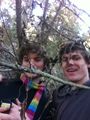
Cam and John at the hash

Felix Dance
I was heading back from lunch with various family members out at South Yarra on my bike at around 4pm. Annoyingly, the puncture I'd collected from an earlier cycle tour evinced a slow leak from my front tire, so I needed to repump it every half hour. Also annoyingly, I didn't have a pump. This was okay getting from the restaurant as a petrol station across the road offered the required facilities. Riding with my brother and his girlfriend to Carlton was also okay as the tyre had only partially deflated by then. However, departing the hash-point, which was the devastated bank of Merri Creek strewn with rubbishy debris from recent floods, I found the bike unrideable. With some luck, today was the day of the Melbourne Roobaix so there were many cyclists out and about helpfully proffering pumps for my ride. This afforded me enough time/distance to arrive at the 30th birthday drinks of which the others speak. Sadly, my trip home afterwards involved many kilometres of walking.
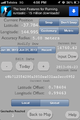
Phone GPS

Felix at the hash
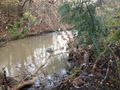
Debris strewn Merri Creek


Stevage
My route home from birthday drinks was along the Merri Creek Trail, so the hash was something like 30m out of my way. Dropped my bike, stomped off into the bushes, wandered through the mud for a few moments guided only by moonlight, and found it without difficulty. For a momemnt I peered at the mud trying to see if I could make out footprints of previous hashers, but it was slightly too dark.
Lachie, Tom A and Miriam
Having failed to coordinate a time with the others I gave up on the hash and went to Miriam's birthday drinks. As Tom, Miriam and I were walking home from the pub we started talking about the hash and quite quickly we had all convinced each other to go. We'd already seen pictures and heard the story from the other expeditions and didn't want to miss out. We stopped at Tom and Miriam's house first to get some warmer clothes then, after a quick kebab stop we continued the walk as the fog descended and the temperature dropped to about 4 degrees. After the two phone GPS reading settled down and stopped saying Tom and I were 200m aparty we reached the hash amongst the bushes at 11:45 pm.
Tracklog
Photos
Achievements
Felix Dance, Stevage, Cam, John and Tom W earned the Bicycle geohash achievement
|
Lachie and Tom W earned the Walk geohash Achievement
|