2013-06-23 49 9
| Sun 23 Jun 2013 in Würzburg: 49.7840435, 9.9946319 geohashing.info google osm bing/os kml crox |
Location
Today's location is on a small path at the town limit of Gerbrunn, next to Würzburg.
Country: Germany; state: Bayern (Bavaria, EU:DE:BY); administrative region: Unterfranken; district: Würzburg rural district
Weather: sunny with clouds
Danatar
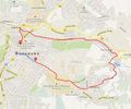
When the coordinates were announced on Friday, they fell conveniently on a small path in Gerbrunn, in walking distance to my place. I almost forgot about them during the weekend, but remembered them in time on Sunday in the afternoon. It was much later than planned and I had sore muscles from running too much, so I took the bike instead of walking. I started at 17:55 and cycled uphill to Gerbrunn. Next to the university the road was closed, so I had to make a small detour, but I was near the hashpoint after 20 minutes. The path starting at the town limit was small and unpaved and I pushed the bike on the last part. Finding the hashpoint was easy, it was just one metre off the path. I didn't get perfect coordinates on my GPS unit because I was trying for a tron geohash and I went 2 or 3 steps too far before taking pictures.
A few moments later I noticed that a young girl with three dogs that I had seen at the town limit was slowly coming along the track. They had to pass the hashpoint. While this was the perfect opportunity for a dog geohash, it probably wouldn't be a nice situation for the girl to meet a strangely acting guy on a remote path, I noticed her glancing towards me multiple times. That's why I continued a bit along the path and proceeded to take pictures of the surroundings, turning my back while she and her dogs passed me. Then I followed them with some distance, until the path reached a street and I could cycle again. I completed the tron route by taking another route on the way back.
I cycled 10.4 km in total.


