2013-06-25 33 -84
| Tue 25 Jun 2013 in Atlanta: 33.7538188, -84.2250190 geohashing.info google osm bing/os kml crox |
Graticule
About
At the end of a residential road South East of Avondale Estates.
Expedition
NWoodruff
From Google maps it looked very easy to reach. The Geohash was at the end of a residential street on a lot that looked to be cleared.
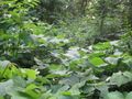
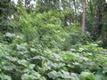
I drove to the end of the street after work and parked my truck. 167 feet to go. I should be easily able to make it. The lot looked very different than the google map picture. It was so over grown that it was difficult to walk in.
Thorny bushes prohibited my forward movement. I made it to 112 feet to go and there was a drop off of about 10 to 15 feet straight down. I climbed around and through more thorny bushes to find a way to make it down. I didn't find one.
So. I settled on my first in a very long time of a Coordinates Not Reached. I snapped a few pictures at 112 feet to go and carefully made my way back to my truck and drove home.
Gallery
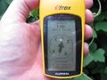
110 feet to go is as close as I could get in the thick underbrush.
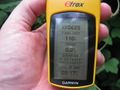
Time of the meetup.
Date of the meetup.
Looking east toward the direction of the actual Geohash spot.
Looking West.
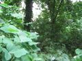
Looking back the direction that I came from.

Me with a Stupid Grin™


