2013-06-26 63 27
| Wed 26 Jun 2013 in 63,27: 63.1687441, 27.9817953 geohashing.info google osm bing/os kml crox |
Location
In Kinahmi, Kuopio.
Participants
- Pastori
- The Wife
Expedition

Pastori and The Wife were visiting their first and so far their only grandchild in Kuopio. When the time came for wistful departure, Pastori noticed that in the trip home (160 km) there was a hashpoint quite near the main road. Into there! But Wife noted that she had left the camera home, so it was no good. Luckily our son (the translator of these texts) had an old digital camera laying in the closet, and it worked, at least we managed to take some test photos.
So we turned the bonnet of our car homewards. We drove on the main road about 50 km and then to the left a gravel road for 4 km. In the beginning of the gravel road there was a sign declaring it to be the most beautiful milk road of Northern Savonia. We were driving on the Milky Way! Splendid! The road went along high up in the forested hills and was a really beautiful old time gravel road.

After about 4 kilometers there was a moment of truth. We would have to go to the forest. Our equipment was not well-suited for this. We had only shorts and t-shirts, the temperature was 30 degrees centigrade and there was a dense forest in front of us, which we knew was holding all sorts of bloodsuckers in it. Well, since we came this far, we may as well put Nokia rubber boots on and foolhardily start our march towards the army of mosquitoes.

From the gravel road there was about 200 meters to the point. First 50 meters went easily on the side of a field, then about same distance along the Tahko bicycle trail. [Editor's note: Tahko MTB XC mountain bike event, which is Finland's largest MTB event, is held at these grounds and the route goes through the above-mentioned trail. Your's truly has participated in the event twice.] But then we had to throw ourselves into the humongous thickets of ferns. Below a barbed wire fence (Pastori and The Wife are still in a pretty flexible condition, because neither tore their clothes), over old trees and through high ferns was our path laid, whose length was only about 80 meters. But there was sweat and waving of hands alright, when we tried to keep most of our "buddies" away from us. After heroic efforts we managed to reach the point. Accordingly the point was in the middle of a pile of brushwood. It is once again proved that "The Sun shines even to the pile of brushwood" (A Finnish saying).

Quickly we took the photographs, the quality of which we didn't have the slightest idea at the moment, and then trudged towards the car. Over the ferns, over the ditches and under the barbed wire. We managed to get out with only slight injuries and leaving only about a deciliter of blood to the local residents of forest.
Otherwise an easy hashpoint, but the hot weather and unsuitable equipment for forest made the visit quite challenging and at least memorable. At home, when transferring the pictures to the computer, there were unfortunately no properly focused pictures of the coordinates, but the closest reading we got was about 5 meters. [Editor's note: I forgot that this camera sucks at macro photographing, it just won't focus on distances below 30 cm or so..]
Additional photos
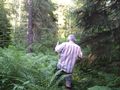
Into the thickets!
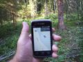
Best picture of coordinates.


Achievements
Pastori and The Wife earned the Land geohash achievement
|