2013-07-29 63 28
| Mon 29 Jul 2013 in 63,28: 63.2971187, 28.2900527 geohashing.info google osm bing/os kml crox |
Location
In Ruohomäki, Rautavaara. The point lies in a forest trail(?).
Participants
Expedition
We were traveling with my family to Valtimo to visit my parents. There happened to be a hash lying almost directly on the route, just waiting to be grabbed. I couldn't miss this opportunity to boost my stats. :)

I had carefully typed in all the necessary intersections to the GPS and made a route of them. However, I didn't realize that when a route is activated for navigation, the Garmin eTrex calculates which point in a route is at that moment closest, and ignores points before that. The major road Kuopio-Valtimo is very bendy and makes at some points 90 degree turns. So when I activated the route, the third point was closest, and the device skipped first two intersections of the route. This resulted in me driving couple of hundred meters past the first intersection, before I noticed that the distance to the waypoint was increasing. I made a U-turn, and proceeded towards the waypoint. Before I could get the hold of the inner workings of the GPS, I made a couple of further wrong turns in the maze of gravel roads. Eventually I could get the GPS to show the waypoint I wanted and found the right intersection to a small forest road.
The road surface was in good condition, it was well-maintained for logging operations. The maintenance didn't, however, include cutting the hay from the middle of the road. This didn't hinder our movement much and I trusted the road-keepers that there weren't any surprise rocks hidden in the hay. There weren't and we quickly reached the end of the (drivable) road. From there it was about 300 meters to the hash.

The Google maps satellite image had shown that there was a some sort of track or roadbed going as far as the hashpoint. There was indeed, but it was almost overgrown by birches and hay. I went on my way anyway with sandals, at least the surface was relatively level. In some parts the tracks was more open and it was quite easy to follow.

Nearing the hashpoint, about 100 meters before it there was a creek. There was a refreshing sound of running water. After the creek, the forest was cut, and the hashpoint was there in the open. I took some pictures and returned. The Sleeping Baby had slept in the car the whole time, and we just continued our journey to Valtimo.
Additional driving distance by car: 6 km. Walking distance: 600 m.
Additional photos
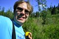
The grin.
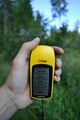
The proof.


Achievements
Tilley earned the Land geohash achievement
|