2013-08-07 32 -117
| Wed 7 Aug 2013 in 32,-117: 32.9344231, -117.0076424 geohashing.info google osm bing/os kml crox |
Location
Atop a ridge off the end of Santa Era in Rancho Encantada, an under-development road and residential zone on the south side of Beeler Canyon in San Diego, CA just south of the border with Poway
Participants
- LucasBrown (independent expedition)
Plans
- Going to a doctor's appointment now and will hit the hashpoint on the way back. Should get to the closest vehicular approach or the end of Stonebridge Parkway (depending on whether I feel like climbing up and down two 200' steepish hills) at 15:10 or so and will walk to the hashpoint from there. -- LucasBrown
Expedition
LucasBrown: I went to the closest vehicular approach—a spot along Via Santa Pradera—at about 15:30 and took my time hiking a few hundred meters across a small valley to reach the hashpoint (reaching it at 15:52) before to the car by walking along the ridgelines under the gentle cooling of a light breeze. I crossed paths with another hiker wearing a dark blue T-shirt and jeans shorts but didn't stop to say hi or anything because speech issues.
- Made it! -- Mathgeek (talk) @32.9344,-117.0076 18:53, 7 August 2013 (PDT)
Tracklog
Photos
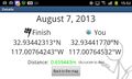
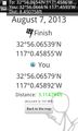
(LucasBrown) Geohash Droid details page at hashpoint
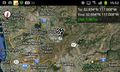
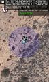
(LucasBrown) Regional map at hashpoint
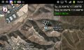
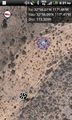
(LucasBrown) Local map at hashpoint
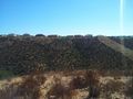
(LucasBrown) The view southwest from the hashpoint
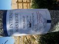
(LucasBrown) Sign posted near the hashpoint at the end of Stonebridge Parkway
Woohoo! @32.9344,-117.0077
Yay! @32.9348,-117.0075
Nearby geocache location.


Achievements
Mathgeek earned the Hash collision achievement
|
LucasBrown earned the Consecutive geohash achievement
|