2013-08-08 63 29
| Thu 8 Aug 2013 in 63,29: 63.8064750, 29.0825230 geohashing.info google osm bing/os kml crox |
Location
In Sivakka, Valtimo. The point lies in a swamp.
Participants
Plans
Tilley w/ family were still visiting Pastori and The Wife. Pastori's daughter, Päivi, was also there having recently returned from Japan. We had been watching hashpoints closely to get a massive meetup even once to these latitudes. As the stay was approaching it's end, conveniently a hashpoint fell relatively close, and we could combine visiting it with some berry- and mushroom-picking.
Expedition

The point was in the Northeastern corner of Valtimo, in the village of Sivakka (population 40). The nearest house is about 1,5 km from the hashpoint. In the area there is a dense network of forest roads, and the point was only about 100 meters from the nearest one. An expedition of this size needs some preparing time, but about half an hour after the previously thought starting-out time we were ready. From the map we could deduce that there could be some bilberries and mushrooms in the slopes of nearby forested hills, so we packed along some picking machines, buckets and baskets.

From the center of Valtimo we turned northwards. First we drove through the village of Ylä-Valtimo (Upper Valtimo), which has a lot of farm houses and extensive fields near the Upper Valtimo Lake. After the village the road started to rise towards the forested hills and the settlements got more rare. Passing by village Sivakka, we turned to the forest road network. The smaller road was actually in better condition than the bigger ones. The forest owners keep these private roads well maintained because they don't want the big 60-ton forest trucks (and in couple of months 76-ton trucks) to get stuck in the roads when hauling their precious wood. Apparently they also have more resources to do the maintaining than the public authorities taking care of the bigger roads. Well, so much of the road politics of Finland, back to the hashing.

There was a nice place in an intersection of roads to park the cars. Tilley's daughter a.k.a. the Sleeping Baby was.. sleeping so we had to let her stay in the car, while Tilley and Pastori eagerly drew their GPS devices and went to do some recon on the hashpoint. They also wanted to test Pastori's new gps device for the car, which also allowed entering in raw coordinates. The hashpoint was quickly found, although it had to be done with the eTrex and smartphone, as the car satnav's coordinate navigation features were too primitive to do any real hashpoint-dance in such a close vicinity of the point. Some pictures were already taken, and then the crew dispersed to search for some bilberries and mushrooms, waiting for the Sleeping Baby to wake up.

After the Baby had finished her nap, we all got again to hashpoint and took the mega-meetup-picture. This unusually big meetup in these latitudes happened in a very usual-looking hashpoint, that is in a swamp dried with ditches. The route from the road to the point was also in a very bland-looking young spruce forest grown strictly to maximize the economic gain. After the picture, we still picked some bilberries before leaving.
After the trip The Wife made some 'mustikkakukko' (a bilberry pie with a rye crust) and the mushrooms we ate the following day with some home-grown potatoes and beetroots. Yummy!
Trip statistics: 70 km of driving. 200 meters of walking (to get to the hashpoint).
Additional photos
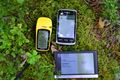
The triple proof.
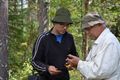
Tilley and Pastori negotiating where the hashpoint actually is.
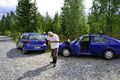
Our parking spot.


Achievements
Tilley, Pastori & co earned the Land geohash achievement
|