2013-08-09 45 -120
| Fri 9 Aug 2013 in 45,-120: 45.7203101, -120.5036295 geohashing.info google osm bing/os kml crox |
Michael5000's Expedition #136
Location
Under powerlines on the north bank of the Columbia Gorge.
Participants
Plans
Cross into Washington at the Biggs Bridge and then approach the hashpoint on Highway 14.
Expedition
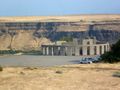
I've had mixed experience with powerline rights-of-way, but they've usually been accessible. These are fairly big-time powerlines from the nearby John Day Dam, however, and my hopes turned to ashes in my mouth from several miles out as I saw that they were going to be fenced off. Nevertheless, I gave it the old geohasher's try. The open gate and remote location would have made informal access easy enough, but I've recently been browsing the geohashing ethical rules and have determined to be Good. I turned around .77 miles from the hashpoint; it would have been possible to get a little closer simply by passing it abeam on the highway, but I decided against the futile gesture. A day spent driving hundreds of miles in order to be twarted at geohashing is its own reward, but has already sufficient futility in it without squeezing out every last drop.
Photos
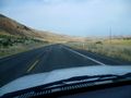
I cross from Oregon to Washington on the Biggs Bridge.
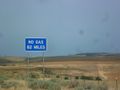
The Washington side of the Gorge is a bit desolate.
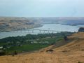
But scenic!
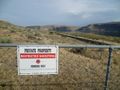
Sadly, I am again twarted.
So I go back to nearby Maryhill and visit the Stonehenge monument!


Achievements
Michael5000 (talk) earned the No trespassing consolation prize
|