2013-08-17 42 -85

| Sat 17 Aug 2013 in 42,-85: 42.9922070, -85.6898030 geohashing.info google osm bing/os kml crox |
Location
side of a residential street on the northwest side of Grand Rapids, Michigan, USA
Participants
Expedition
We're back in Michigan having completed our year in the 54 -1 graticule. Today's the first good opportunity for geohashing, and the point is right up here in our part of the rectangle, and right on a city street to boot so it looks like a good opening for Tron; what luck! (It will be a car Tron, not a bike one.)
Rebekah and I planned out a first-draft route on the map while sitting in the driveway. We live on a cul-de-sac, and in North America we drive on the right, so the big loop would have to be counterclockwise if we wanted to get back home without crossing the outbound path. In addition the hashpoint is on the west side of its street so we needed to be headed south when we reached it. There was a fair amount of worst-case strategizing during the trip up there about what we'd do if the street was one-way the wrong way. We encountered one Road Closed sign, but there was an easy detour from our original plan that didn't affect the basic loop structure.
When we arrived at the north end of the street containing the hashpoint, there was thankfully no One Way sign. The point was between the sidewalk and the street, next to a driveway; there was a van parked on the street there, with its nose almost even with the hashpoint, so we had to drive just past the van (passing less than 2 meters from the hashpoint) and park just south of the driveway. The street-sign shot shows signs at the southeast corner of the intersection of Richmond and Jenette; it was taken from the hashpoint. We're claiming a No Batteries award, which honestly is low-hanging fruit in a city with a grid layout.
As we were pulling against the curb, an ice cream truck was northbound on the street, so we flagged it down and bought two ice cream bars before we took pictures and wrote XKCD on the curb with chalk. There oughta be an ice-cream-truck achievement, doncha think?
On the way home we continued southbound, and connected to the US131 freeway. We had to pass up the most natural exit (Burton Street) for the trip home because it is a partial cloverleaf and would have involved a 270 degree turn. The next one (28th St) was a simple ramp-to-T exit, and that got us home. When we approached the home cul-de-sac we were careful to turn in and drive all the way down the street on the right, make the big U-turn at the bottom, and return to the point just south of the driveway from where our trip started. Tron loop completed!
Rebekah wrote down the sequence of streets as we followed them: Outbound: Asbury(northbound),Brighton,Boston,Plymouth,Lake,Fuller,Leonard,Plainfield(forced by closure on Leonard before the westbound bridge over the river),Ann,Alpine,Richmond,Jenette(southbound).The hashpoint was on the west side of Jenette, just south of Richmond. Return: Jenette(continuing southbound), Myrtle, Alpine (different segment, farther south than previously), Stocking, Bridge, Seward,Lake Michigan Drive, US131 south, 28th,Eastern,Alger, Plymouth(different segment than outbound, again farther south),Elliott,Lotus,Griggs,Woodward,Orville,Tenway,Englewood,Asbury(southbound), then U-turn at end of Asbury and continuing north along Asbury to reach the start point.
Photos
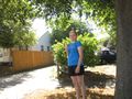
Rebekah just north of hashpoint with her ice cream. Behind the bush behind her, you can make out the wall of a garage; this wall is on the line of the hashpoint, about a meter south of where she is standing.
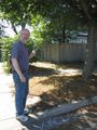
George with his ice cream, at the chalked marker.
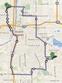
Map with our loop route drawn in. Note that the start point A is buried under pin C. The start point is on the east side of a cul-de-sac on Asbury; the route left northbound from there, crossed Englewood, and continued to points north. The return approached from the west on Englewood, turned south onto Asbury, made the counterclockwise U-turn at the south end of Asbury, and continued north to the start point, not intersecting the outbound route until the closure.


Achievements
George and Rebekah earned the Land geohash achievement
|
George and Rebekah earned the Tron achievement
|
George and Rebekah earned the No Batteries Geohash Achievement
|