2013-09-02 45 -68
| Mon 2 Sep 2013 in 45,-68: 45.6028551, -68.8134778 geohashing.info google osm bing/os kml crox |
Location
Off Highway 11 southwest of Millinocket.
Participants
Plans
We are going to see what we can do with this hashpoint from a base camp in Waterville. It looks pretty doable, but it's hard to say for sure without being familiar with forest density and access norms in this part of the world.
Expedition
From a base camp in Waterville, we traveled through Dover-Foxcroft and up the fringe of civilization on State Highway 11 to the area of the hashpoint. Access was easy due to the presence of a snowmobile trail, something new to us who aren't from the area. Rain gushing down made even just crossing the highway very wet work, but 200 meters through medium-dense forest was downright soaking. Unfortunately, this may have led to the premature demise of my beloved camera. But we were undaunted, and made our way to an especially damp section of the woods.
We felt appropriately triumphant, then tramped our way back out, and then spent a while trying to get ourselves relatively dry before heading northeast to say hello to Aroostook County. Because of the rain, we had abandoned our plan to try 2013-09-02 45 -69 earlier in the day, but somehow still ended up doing 2013-09-02 45 -67 afterwards.
National Weather Service report for September 2 rainfall in Millinocket: 1.34 inches.
Photos
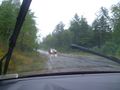
A rainy rainy day in Maine
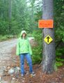
Mrs.5000 on the snowmobile path
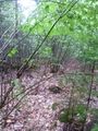
200 meters through soaking forest

The Bear at the hashpoint as the camera starts to fail
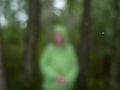
Mrs.5000 at the hashpoint, the camera having failed


Achievements
Michael5000 and Mrs.5000 earned the Graticule Unlocked Achievement
|
Michael5000 and Mrs.5000 earned the Drowned Rat Geohash Achievement
|