2013-09-18 -34 142
| Wed 18 Sep 2013 in -34,142: -34.3777205, 142.1016529 geohashing.info google osm bing/os kml crox |
Contents
[hide]Location
On a dirt road near Red Cliffs.
Who went
Expedition
This all started a few weeks ago when Tom and my mutual friend Stevage showed us a website he'd been working on mapping all the cycle tours our friends had done. This map showed a considerable dearth of touring in the North West region of Victoria, and so a tour to fill in the gap was conceived.
Tom and I took the train to Swan Hill on Monday night with our road bikes, lycra clothing and credit cards (it being a credit card tour to save weight and clock up distances). We stayed in motels most nights on our 220kms ride to Mildura, 242kms ride from Mildura to Hopetoun, 200kms from Hopetoun to Ararat, and 112kms from Ararat to Ballarat station for our trip home.
After meeting a friend for breakfast in Mildura on the Wednesday morning, we rode down the Sunrasia Highway for many gruelling kilometres, passing an enormous crude-oil fuelled desert engine named Big Lizzy in Red Cliffs, and debated going for the geohash that day. It seemed pretty inevitable that we'd go for it, particularly seeing as we'd missed out on the previous day's hash across the Murray River.
Riding into a horrid headwind we turned off onto the dirt track towards the hash. After a few kms, we turned west again and counted down the metres until the hash, right on the dirt road itself, appeared before us. Happily having taken photos we headed back towards the highway, where we encountered a blue-tongue lizard petulantly baring its blue tongue at us and so much sandiness we had to walk for some distance lest our bikes sink into the soft track. This section of the Google Maps track is incorrect in the link below, because Google didn't recognise the connection over the railway line to the highway.
We rode south for some distance before realising there was a possibility of achieving a SECOND geohash for that day...
To be continued 2013-09-18 -35 142...
Our route for the whole tour is here
Photos
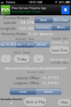
Phone GPS Proof
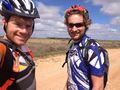
Felix and Tom at the hash
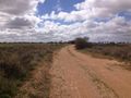
The dirt hashroad


Achievement
Felix Dance and Tom earned the Land geohash achievement
|
Felix Dance and Tom earned the Multihash Achievement
|
Felix Dance and Tom earned the Bicycle geohash achievement
|
Felix Dance and Tom earned the Graticule Unlocked Achievement
|