2013-10-01 -37 145
| Tue 1 Oct 2013 in -37,145: -37.7569445, 145.5651056 geohashing.info google osm bing/os kml crox |
Location
In a swamp, on a farm to the north of Launching Place - a small town not far east of Melbourne.
Participants
Plans
I got home from the previous nights geohash just as new coordinates came out and saw it was near the base of Donna Buang. I've ridden up Donna before and was keen to do so again. This trip would also mean riding along the Warburton Rail Trail which is a great path and possibly visiting some friends in Seville so I couldn't really justify not going.
Expedition
After planning my route at home and packing supplies for the day I left home to ride down to Flinders Street Station, I hesitated as I pulled out of my alley way and decided I should take a rain coat even though it was sunny. This was possible the best decision of my life. My train ride out to Lilydale was uneventful, before i set out from Lilydale to start my adventure I stopped at the shops for some snacks and sunglasses. I have a habbit of leaving sunglasses in country towns around Australia and hadn't replaced them since South Traralgon claimed my last pair.
I set off on my ride along the all to familiar Warburton Rail Trail. It's usually a very dusty trail but it was raining so within a few minutes my recently cleaned bike, my brand new sunglasses and I were completely covered in mud. After not to long I reached Worri Yallock where I turned off the trail and onto the roads. The rain was getting pretty heavy but I fins myself at a farm house 90m from the hash a little after 1pm. Being broad daylight and with the hash being so close to the house I knocked on the door to ask for permission. I was greeted by a friendly lady wearing dish gloves who seemed a little confused by my request but cheerfully granted me access.
I wandered down into the paddocks and with about 40 metres to go realised it wasn't going to be in the paddock but rather amongst trees and reeds in a swamp. Doing the usual GPS dance I climbed the same fence three times and waded in. Success! hash reached at 1:30pm.
While this was the end of the journey to the hash I wasn't going to come all the way out to the bottom of a mountain and not ride up it. The route from there on followed a bike ride i tried to go on with fellow geohasher Felix. My previous attempt at riding up this side of Donna Buang failed due to me riding a road bike to fast on dirt roads and breaking a few spokes. I sat on the side of the road for a few hours while Felix went to get the car.
As I approached the top of the Mountain I noticed some white stuff on the side of the road, it took me a little while to process what it was. I hadn't seen snow since I was eight and I thought it was too late in the year to find any this far down. I was extremely excited and stopped to take a photo of the first little clump. I felt a little silly given I saw much more as I continued the climb. I reached the top of the Mountain and climbed the lookout tower. It was windy, raining, foggy and I couldn't see much so I didn't stay long. Just as I was about to ride down the mountain the weather got much worse which annoyed me at first. Then it started snowing. I was beside myself with excitement never having seen snow before. I danced around in it a little bit, caught some in my hands, and then remembered I was wearing shorts, a shirt, a light rain coat and shoes filled with swamp juice and I was really cold so I started to ride down the mountain. It then occurred to me that I WAS RIDING MY BIKE IN THE SNOW and once again I was far to excited to care about the cold.
I'm fairly slack with bike maintenance so I didn't have much in the way of brakes. It was a rather scary ride down the mountain in the snow, my brakes were on full the whole time and I was cruising at about 30 k/h. My raincoat was keeping my body warm and dry and the sunglasses meant I could see, these two factors comforted me greatly. After rolling the 18km into Warburton and releasing the brakes for the first time I found that my fingers could no longer be straightened so I pulled into the servo to run them under water and warm them up. This proved harder than I expected as the toilet door was locked. I had the key to open it but lacked the manual dexterity to turn a key so it took me a while to get in. Turning on the tap was also a challenge. I should wear gloves.
From Warburton I rode back along the rail trail to Seville where my friends Nathan and Adelle had beer and a parma waiting for me, arriving at their house a little after eight. After a delightful catchup Nathan drove me to Lilydale station and I headed home.
Total bike riding distance for the day including trips to and from the station = 116km.
I took some photos at top of the mountain but my phone said no SD card, I thought this meant it would save them to the internal storage but apparently not. Last time I was on top of Donna Buang my radio stopped working but started again at lower altitude. It must be something in the air.
Tracklog
here's the route I took. http://goo.gl/maps/1eYOw
Photos
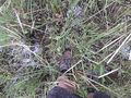
muddy feet
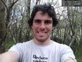
Swamp hash success @-37.7569,145.5650
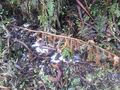
SNOW!
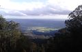
View of the Yarra Valley from half way up the mountain.


Achievements
- Land Geohash