2013-10-01 62 27
| Tue 1 Oct 2013 in 62,27: 62.7569445, 27.5651056 geohashing.info google osm bing/os kml crox |
Location
In Pellesmäki, Kuopio. The point is in forest.
Participants
- Tilley
- Tilley's daughter
Plans
The end of August and whole September have been very busy for our family, mostly because of my wife's studies. Me and my daughter have been at home to take care of the household. Of course we have cycled a lot around the neighborhood, but reaching any hashpoints has not been possible. There haven't been any land-based points within reasonable cycling distance, and going kayaking isn't an option with the baby. In addition to that we have temporarily decommissioned our car; we are going to use it next time when it's time to go to Christmas vacation. Therefore I was very eager to do a geohashing expedition after a long pause when a suitable opportunity presented itself: a hashpoint only 14 km (by road) from us. And quite near the main road, too. Doing the trip in an old-fashioned Sleeping-Beauty -style (look for my earlier expeditions if you don't know what that means) would even be possible.
We will most likely be starting our expedition at the baby's naptime, that is between 12-13.
Expedition

After eating some Norwegian salmon for lunch along with potatoes and carrots Pastori and The Wife had grown in their garden we set out at 12:30. The weather was very autumn-like. Temperature 4 degrees, northern wind 4 m/s. This was actually quite good weather to ride my heavy cargo bike, there was no risk of overheating myself. The wind I was a bit worried about, it would be headwind on the way back. Beautiful yellow and red leaves lined the road as we navigated through the suburbs to reach the old main road number 5.

First few kilometers were familiar; we had ridden that way many times going hashing, because it is the only practical way south. After the 8 km mark we ventured into uncharted territory. The surface of the bicycle way got immediately worse with big cracks across the whole road. After a kilometer, the bicycle way ended altogether and I had to start cycling on the road shoulder. Fortunately this road hadn't had much traffic since the Kuopio motorway got completed about a decade ago. Only about a dozen cars passed us on the 5 km stretch. However, there was some evidence that this is not always the safest road; someone had lost control of their car and run down a light pole before coming to stop into the ditch. The tracks were fresh, the car was still there and the light pole unfixed, so the accident must have happened the night before. The car was not seriously damaged, fortunately.

After the scene of accident there was only a couple of kilometers to go. The right place was quickly found, and the gps showed that the hashpoint lay about 60 meters off-road. I made a U-turn and parked the bike on the roadside. The baby was soundly asleep. I did not disturb her. The terrain was clear-cut forest, and I quickly reached the right spot. GPS reception was very good, and I could get a sub-one-meter reading. Couple of quick photos and back to the bike!

On the way back I picked up a couple of geocaches. The headwind did not feel as strong as I had feared, and the trip went quickly. A couple of cars whizzed by pretty close. How it is so hard to turn the wheel just a little bit and pass a bicyclist with a safe margin? There would have been plenty of room even when staying on the lane. These drivers just didn't move an inch sideways from their normal driving path.
The baby awakened about 5 km before home, which we reached safely. We then went on to have some afternoon snack which tasted good for both the passenger and the driver.
Statistics: Distance traveled 28,5 km, "moving average" 18,6 km/h, maximum speed 46,8 km/h.
Additional photos
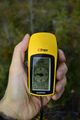
The gps proof.

Achievements
Tilley earned the Bicycle geohash achievement
|
Tilley earned the Land geohash achievement
|