2013-10-05 49 -123
| Have you seen our geohashing marker? We'd love to hear from you! Click here to say "hi" and tell us what you've seen!
Curious about what geohashing is? Read more! |
| Sat 5 Oct 2013 in Vancouver: 49.5288289, -123.2432313 geohashing.info google osm bing/os kml crox |
Location
Near the Deeks Lake trail.
Participants
Plans
Planning to be at the trailhead near Porteau Road around 3-3:30pm, will hike to the coordinates. Wish me luck!
Expedition
Rex
I arrive late to the trailhead. My lunch was late owing to the other party getting lost along the way, and I underestimated the amount of time required to get up to the trailhead from Ladner. No matter--it's my first geohashing expedition, and the adventure is what counts!
The trail is supposed to start very steeply, and I hope I can manage it. From what I've read, though, it only rises about 150 meters at the start, and then is easier from there. Should be fine.
Having parked in the Porteau Road lot along the Sea-to-Sky highway, I can see the start of the trail. It curves sharply away to the right and immediately starts climbing. There's some truth to what the trail guides say--you could definitely have an easier time of this if you took a 4x4 vehicle up the trail. It's wide enough, and it still has some remnants of asphalt.
I meet two people coming down the trail, and they ask me if I'm going up to close the gate. I don't know why everybody always thinks I'm some sort of official. This time, maybe it has to do with the laminated sign I brought with me to post at the coordinates. I smile and tell them that I'm not here to close anything, and they continue on down.
The trail certainly is steep, and my lower back is complaining about it more than I thought it would. I console myself with the thought that this is only for a short distance. Meanwhile, it's quite pretty out. There's birds chirping, the sun is behind the clouds, and it's neither too cool nor too hot.
I'm huffing and puffing like a bellows by the time the ground levels out a little. There's a solid wooden bridge over a lovely little waterfall (I can't resist taking a picture here), with the asphalt continuing afterwards. But the asphalt soon crumbles away into gravel and grass. I take another picture of the mountains, wreathed with little clouds.
The trail starts climbing steeply again, and I continue laboring my way upwards. The path is very badly eroded along here, with runoff having sluiced away most of the ground to reveal the gravel and larger rocks underneath. I'm having a difficult time of it, but at least the way back will be easier. I stop for several minutes to sit on a rock and rest my back before pressing on.
Finally the slope eases into a gentle undulation. I'm relieved; I was beginning to think I wouldn't be able to make it all the way. There's a signpost that helpfully tells me that the parking lot is a mere 0.8 km behind me. (Which puts the coordinates about 2 km ahead of me.) I feel like such a weakling.
It's nice along this section, though. The path isn't washed out, and there's puddles pooling all the recent rainfall. I haven't seen a single person since I crossed paths with the two right at the start of the trail, and I'm starting to realize that this is less the easy trail I thought it was, and much more of a hiking path through bear country. And here I am, alone, with nothing but a hammer to deter bears or other wildlife, in the late afternoon, on a mountain. Perhaps my planning omitted a few items.
I've moved forward quite a bit when I round a corner and see, to my utter dismay, that the path is heading steeply upwards again. I check my GPS and curse fluidly under my breath as I suddenly take note of the contour lines indicating that I have another 80 or 90 meters to climb. I seriously consider chickening out here, until I check my path and realize I'm 70% of the way to the coordinates. Damned if I'm going to give up now.
Climbing further upwards has raised my heart rate and put more tension on my lower back again, and I'm having to take frequent pauses to unlock my lower back. I notice that I'm actually climbing into a cloud at this point, since there's a line of cloud floating just above my head, and the path goes upwards through it.
I climb for a little while longer, and at some point I realize that there are no bird noises any more. Either that's a bad sign, or I'm just being too noisy and scaring the wildlife away. The sound of running water alerts me to another waterfall, and I snap a picture even though the waterfall doesn't show up very well. Looping around the bend, I recross the same waterfall, but the upper part is much more photo-worthy, and I take another picture.
I have to stop and sit again to rest my back. The mostly-level stretch was fine, but the steep climb sections are just killing me. Again, I think about just calling it a day of good exercise and heading home, but I'm getting so close to the destination coordinates! There's a sudden noise of a motor, and I watch as a Kawasaki dirt bike comes sliding down the slope. I nod to the rider, and he nods to me, but then he's off and soon I have the silence of the forest around me again.
Lurching back to my feet, I push onwards and upwards through the final stretches, checking my GPS frequently. I don't intend to go much further than I have to! The coordinates are slightly off to the left of the trail, but I should be able to get out there, I think.
Perhaps not so much, as it turns out. The brush is pretty well interwoven here. I push off the trail anyways, but I can't get far enough to get my GPS to update correctly. Never mind, any further and I'd plunge over the edge of the ravine anyways. I tack up the poster and snap a picture of it, followed by a picture of the ravine where I'd end up if I went any further.
Walking back down is much nicer, and I don't have to stop for breath. Pretty soon, though, I find that instead of my back hurting, all the weight is now being transferred through my knees, and now they've started to rebel. It's bad enough that I have to stop a few times to just give them a moment to stabilize themselves. The tendancy for the gravel to act as a rolling ball bearing under my feet doesn't help matters at all.
It's about this time that I realize that I didn't take a screenshot of my GPS displaying coordinates, or take a mug shot of myself with the marker I left. Confound it all, but I'm not climbing back up there for that.
I'm almost to the flat section again when I'm startled by a very sudden engine noise. I jump off the path in time to see a Toyota RAV4 come barreling along the way. It stops, and a window rolls down to ask if I need a ride. I automatically give my usual, "No, I'm good, thanks!" and the occupants smile and continue on their merry way. I'm watching the car disappear as I start cursing at myself again for having passed up such a wonderful opportunity to get the hitchhiking achievement!
Oh well. I keep heading back down the trail, making very good time along the flat bit. The really washed-out steep section with the big rocks is tricky, but I keep working my way down, trying to prevent my knees from giving way altogether. My ankles have also started to complain, having been turned awkwardly a few times by now. I also note, with some trepidation, that the forest is getting darker and cooler. Nightfall will arrive sooner than I anticipated--but I've also been out longer than I ever expected. Though I'm not really alarmed--I'm dressed warmly enough, my activity is keeping me very warm, and I have a simple trail to follow to get back to my car. At least the bird noises are back. I guess they just don't go further up the mountain.
It doesn't seem too long before I hit the ruined asphalt, cross the wooden bridge, and go winding back down through the initial steepness. How silly the whole thing seems to me! I grossly underestimated the vertical climb and didn't plan fully to trek out into the wilderness, trail or no trail. If I do this again, I'm going to have to plan better.
Then again, I don't suppose I'll be coming back to this hashpoint, at least not for a while. It's good to get back to my car. I've had myself an expedition, all right!
Tracklog
Photos
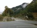
The start of the trail, seen from the parking lot.
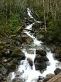
Waterfall near the wooden bridge.
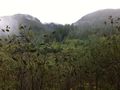
Mountainside along the trail.
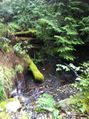
Lower section of the second waterfall.
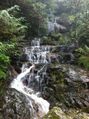
Upper section of the second waterfall.
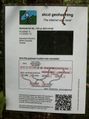
The sign is posted!
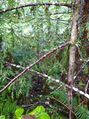
Any further, and I'll be in that ravine.


Achievements
Rex earned the Land geohash achievement
|