2013-10-11 1 103
| Fri 11 Oct 2013 in 1,103: 1.3631470, 103.8813477 geohashing.info google osm bing/os kml crox |
Contents
[hide]Location
On the pavement along Richards Avenue.
Participants
Plans
Leave early, take the train, voila - hash!
Expedition
I work in the afternoon, so if I wanted to get here in time I'd have to leave a little earlier than usual, at 11.30am. To get to the hashpoint I had to change trains twice, from the North-South Line to the Circle Line at Bishan and then finally to the North-East Line at Serangoon. On the way to Bishan I saw dark clouds looming in the horizon, and I realised I hadn't brought an umbrella with me. If it rained...well, heck it, I've got a hooded overshirt, that works.
The interesting thing about this geohash is that it's in the area where my primary school (Rosyth School) was located back in the 1950s. The school not only took its name from one of the roads there, it also derived its house names from the streets in the area - Glasgow, Phillips, Kovan, Jansen and Richards. I was in Richards house when I went to school there, and having a geohash at Richards Avenue seemed like a pretty good coincidence.
It was raining when I got there, but not too badly. I walked along Lowland Road and luckily there was a shortcut through to Richards Avenue at a turn near the end of the street. Snapped a few quick pictures and left. Got to work with enough time on the side to buy lunch and eat it, too.
Photos
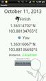
Coordinates reached!

Obligatory grin
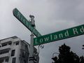
My old school house was named Richards


