2013-10-20 50 -120
| Sun 20 Oct 2013 in 50,-120: 50.6560083, -120.2360833 geohashing.info google osm bing/os kml crox |
Location
In the hills south of (above) our subdivision. Because it's always uphill to the geohash.
Participants
- Rhonda
- Rhonda's Mom
- James
Planning
On friday Rhonda came up and we were discussing whether there was a hash point easily accessible this weekend.
Expedition
While deciding to walk up to the hashpoint we figured we may be able to get a tron achievement for this day. To do that, we left the house and walked away from the hashpoint, and went up the more southerly parallel street. There were two easy spots that we knew of to get into the hills south of the community without crossing anybody's yard, so we took the first one, west of the hashpoint, on the way there, with plans to come back to the street on the second one, east of the hashpoint.
Just as we started climbing the hill and were discussing what the best route would be, a stranger shouted from his backyard, "the trail is a hundred feet further up!" So we thanked him and climbed straight uphill and found the trail. It was running along the side hill and almost exactly toward the hashpoint, and we congratulated ourselves on finding a good trail. Usually we find good trails on the way out.
We stepped over a fallen tree, crawled under another fallen tree, crossed a section of slope that was steep enough that we had to hang on to fistfuls of bunch grass so we didn't slide down the hill, looked at mushrooms of several sorts, stepped over deer droppings, and debated which fork in the path to take then had to leave the path anyway.
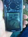
The GPS dance was short because we were on a north face and our accuracy was about 15m. Rhonda picked a tree that was about as close as GPS accuracy would allow us to determine and called that the hashpoint, so we could put our feet against it and not slide downhill while we sat down and took pictures.
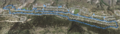
After remembering to take photos (but only because James the dragalong had the only camera(phone) in the group) and forgetting to leave a marker, we continued eastbound - but first we went downhill through a patch of trees so we could hang on to them, to get to a flatter spot that would be easier walking. After a short trek through some thistle bushes we got back on pavement and turned west again, and successfully got one street over before crossing our path. It's a good thing we didn't decide to risk trying for a track on either side of a street, because the accuracy was kind of weird and google maps showed that we hopped from roof to roof on the way back.
Photos
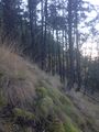
It was a steep climb
but we made it!

and were still smiling, too
especially when we finished the tron loop


Achievements
Rhonda and Rhonda's mom earned the Tron achievement
|
Rhonda earned the Drag-along achievement
|