2013-11-06 32 -82
| Wed 6 Nov 2013 in 32,-82: 32.8527026, -82.9197188 geohashing.info google osm bing/os kml crox |
Location
On Old Ohoopee Church Road 2.9 kilometers east of Oconee, Washington Co, GA, USA.
Participants
Plans
Thought I would try a two-fer today. This was part two of my afternoon. I have been wanting to take a long trip and this seemed like a good adventure. The hash was not too far southeast of Milledgeville, GA, which I am familiar with.
Expedition
Left the Athens, GA hash for today (2013-11-06 33 -83) and headed towards the Vidalia, GA hash. I used a familiar route via Milledgeville. I've always enjoyed the drive to Milledgeville as I have made it many, many times travelling to college and to visit my father.
I made a small detour to visit the small town of Shady Dale. See the picture below of the charming City Hall that is located in the old bank building.
I arrived in Milledgeville and drove around to see some of the places I remember from my college days. Milledgeville was the capitol city of Georgia from 1807 to the end of the Civil War in 1865. The Old Capitol Building has served as the center of the campus of Georgia Military College since its founding in 1879.
Had a great barbecue chicken meal thanks to a fundraiser hosted by the GMC prep school. I looked around some at the new additions to the college and construction in progress on campus. See the picture below of the Old Capitol Building.
I decided I’d better get on with finding the hash as it was getting late in the afternoon. Left Milledgeville and headed towards Washington County. This area is known for mining of kaolin (clay-like mineral used in paper finishing and making of porcelain, as well as other uses).
Unfortunately, I left town without purchasing gas for the car. The last place I saw that offered gas was inexplicably named "Rip-Off Ricks". I kept thinking that I would see a station, but kept going farther away from developed areas. I got pretty close to the hash but then decided I needed to get gas first. Made a trip to Tennille and filled up.
Because of my dawdling in Milledgeville, the side-trip for gas, and my forgetting to check for the sunset time before I started, I arrived at the hash just as dark set in. The journey included a 5.5 kilometer trip down a red clay and gravel road (well maintained). It seems that the area around the hash is used by the forestry industry. Just south of the hash a vast area seems to have recently harvested for timber.
I knew I would get no pictures at the hash due to the lack of light. I soldiered on and located the spot and snapped the picture below of my (backlit) GPS screen.
I met only one person while in the area. A rather gruff fellow in a white work truck drove up and asked my business. I told him "the Internet sent me" and I was leaving, immediately. He favored me with an escort to the county line. I made the drive out expecting an intercept by local law enforcement.
The drive home was uneventful. I spent the time listening to old country songs and pondering the wisdom of being in the middle of nowhere (no offense, Oconee, Georgia), after dark, with no good explanation of why for the locals.
Photos
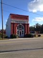
Shady Dale City Hall
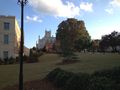
Georgia Old Capitol, Milledgeville

Picture of GPS


Achievements
Tomkf61 earned the Graticule Unlocked Achievement
|
Tomkf61 achieved level 3 of the Minesweeper Geohash achievement
|
Tomkf61 earned the Multihash Achievement
|