2013-11-22 49 9
| Fri 22 Nov 2013 in Würzburg: 49.9443124, 9.4157302 geohashing.info google osm bing/os kml crox |
Location
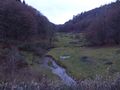
Today's location is in the forest in the Hafenlohr valley near Weibersbrunn.
Country: Germany; state: Bayern (Bavaria, EU:DE:BY); administrative region: Unterfranken; district: Aschaffenburg rural district
Expedition
Danatar
After coming back from my vacation, I had to drive from my parents' place to Würzburg again. Taking the northern route around the Odenwald, I came into the vicinity of this hashpoint. I left the Autobahn at Weibersbrunn and drove along the country roads, parking the car at the beginning of the forest track nearest to the hashpoint. From there I walked along said track. The hashpoint was almost straight north from my car, but the track lead to the northeast for a while. Since I knew the layout of those tracks, after a while I took a shortcut straight up a hillside to the next track, then I followed that one. Soon I was near the hashpoint. At the exact coordinates I took pictures, made a marker and did all the other usual stuff. After that, my GPS unit told me, that I was now - without moving from the spot - 18 m away from the hashpoint. When I went into the direction towards the new location, the hashpoint jumped back in the direction it had been before. Well, one hashpoint is enough, I didn't continue chasing it. In reaching the spot, I had zoomed in on my GPS unit's map and I had noticed that the forest tracks were in that map after all, they just hadn't been displayed in the other zoom level. Now I could see a much shorter route which lead me straight to my car. It was along just a small dirt track. I had seen the end of that track when starting but I had dismissed it because "it will probably end after a few meters".

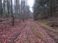
almost there
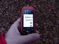
GPS

coordinates reached!

the hashpoint

panorama

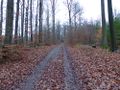
track on my way back


food, or bait?


