2013-12-03 47 11
| Have you seen our geohashing marker? We'd love to hear from you! Click here to say "hi" and tell us what you've seen!
Curious about what geohashing is? Read more! |

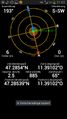
| Tue 3 Dec 2013 in 47,11: 47.2853997, 11.3910260 geohashing.info google osm bing/os kml crox |
Location
The driveway of some very fancy houses at Hungerburg, Innsbruck.
Participants
Expedition 1
Expedition 2
- RunningSushi
- EleanorAbernathy
- LeslieHapablap (previous|next)
- Waltraud the hashkiwi.
Plans
- Too close not to go. -- LeslieHapablap (talk) 17:07, 2 December 2013 (CET)
- This could have been the largest meetup in the Innsbruck graticule, but unfortunately we could not find a time which was convenient for everyone. This is why two expeditions are planned, one with people on unicycles (Expedition 1) and one with people jogging/joggling (Expedition 2). Expedition 1 is already on its way as I'm writing this (2:45 p.m.), Expedition 2 will start at approximately 8 p.m. It will still be the record of our graticule so far in the category most people visiting. --LeslieHapablap (talk) 14:47, 3 December 2013 (CET)
Expeditions

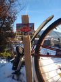
Expedition 1 Expedition started at different places spread all over Innsbruck. 1-0 started in the east of Innbsruck passing by Mühlauer Aussicht. OwlOnAWheel started west and took the cablecar to the station. UpsideDown arrived sweating just with T-shirt in the snow. We met at "Hungerburg Bergstation" and all of us arived half an our late, as it is a steep and long uphill. While waiting 1-0 got some Postcards for Expedition 2. Together we unicycled the last meter to the Hashpoint. As far as we know this is the most (3) Unicycles at a Hashpoint. We did not use a GPS device as this point was easy to find. We could enjoy the great view around the valley and up to the Mountains. When we finished our Postcard for Waltraud a Postman stoped by at the Hashpoint. We left some markers for Expedition 2 and enjoyed the great feeling of melting snow inside our shooes. Then we made our way back down the easy rideable hiking trail to Alpenzoo.
[Editor's note: some of the group disagreed with the classification of an "easy hiking trail". Here is OwlOnAWheel's description:] 1-0 suggested to ride down through the forest on what he called a "flat and easy trail", which turned out to be icy and quite steep... but still really fun to ride!
Expedition 2 For quite some time now we wanted to try joggling (juggling while jogging) with our glow balls at night. Finding this hashpoint in moderate jogging distance of about 4 km one way, although with about 300 m altitude to climb, was giving us a little bit of extra motivation.

With tempteratures below 0°C we put on some extra layers of clothes and started into the dark at about 8 p.m. Knowing that Expedition 1 has already conquered the hashpoint and having seen some nice pictures of unicycling geohashers, perfect weather and scenic views, we knew we couldn't fail without hearing about it for weeks to come. 1-0 has even bought some postcards of the hashpoint area on his expedition and handed them to me when we met between expeditions. I kindly asked him to do so because I knew all the shops would be closed when we arrive, but still for the hashcard achievement it is encouraged to buy the cards on the expedition. To my knowledge this is the first time hashcards are acquired on one expedition, but written and sent on a different one.
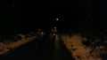
The way up to Hungerburg lead us through the narrow streets of the village Hötting (part of Innsbruck), and then on a very steep road up to Gramartboden. With RunningSushi and LeslieHapablap joggling, EleanorAbernathy was jogging a few meters behind to collect any dropped balls if this should happen. Unfortunately the glow balls bounce and roll quite well and therefore have a tendency to escape. But everything went well and we reached the plateau on which the settlement Hungerburg together with todays hashpoint lies without losses.

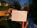
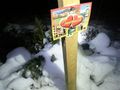
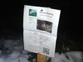
When we arrived at the driveway where the coordinates were anticipated and the gps confirmed that we had reached the point, we saw a postcard pinned to a wooden post with an xkcd marking, together with some sweets. It was addressed to our hashkiwi Waltraud and also contained greetings to the rest of the group of Expedition 2. So Expedition 1 has not only bought us some hashcards to use ourselves, they have also written one to us! The rules state the hashcard has to be acquired and sent while still on the expedition. It says nothing about mailing, and I would argue leaving a card where you are sure the recipient will find it is an appropriate way of sending, and the achievement applies. Therefore, to honor this creative loophole, I will award the ribbon on Waltraud's behalf.
We took the obligatory group picture, wrote our two hashcards and addressed them to Norway and Switzerland, respectively (hashpoint marked with an x), and wanted to leave as soon as possible because it was getting very chilly while not moving. At the last moment we remembered that 1-0 has told us about two markers they left. We looked around with our torch light, and indeed saw tracks in the snow which clearly resembled a huge unicycle. Unfortunately it was impossible to take a picture of this in the dark.
LeslieHapablap is claiming the déjà vu geohash, evidence is a gps track from June passing today's hashpoint at a distance of about 30 m.
Photos
Expedition 1
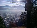
Mühlauer Aussicht. No exaggeration.

1-0 cannot quite decide which is the most beautiful postcard here.
Smiling unicycles.
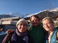
Smiling geohashers. From left to right: OwlOnAWheel, 1-0 and UpsideDown
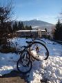
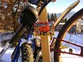
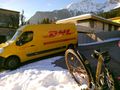
This vehicle is powered by renewable energy.
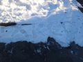
Marker in the snow.
Dear Waltraud...
Hashcard for Waltraud.
Hashcard waiting for the recipient.

Different perception of temperature.
Another geohasher? More hashcards?
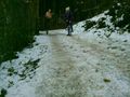
The way down, not for the faint of heart.


Expedition 2
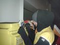
Joggling with glow balls.
The first marker of expedition 1.
We put our poster there instead. The card was addressed to Waltraud after all... hers to take.
Obligatory proof.
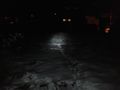
Temperature -4 °C.
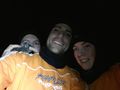
Obligatory silly grin picture.
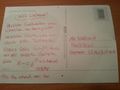
Back side of Waltraud's hashcard.
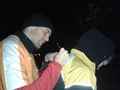
Writing the hashcards.
Tracks in the snow, the second marker of expedition 1 (a unicycle, but it's too dark).
Sending the hashcards.
Hashcard received! @59.9422,10.5196


Achievements
All participants earned the Land geohash achievement
|
1-0, OwlOnAWheel and UpsideDown earned the No Batteries Geohash Achievement
|
1-0, OwlOnAWheel and UpsideDown earned the Circus Geohash Achievement
|
1-0, OwlOnAWheel and UpsideDown earned the Hashcard achievement
|
RunningSushi, EleanorAbernathy and LeslieHapablap earned the Walk geohash Achievement
|
RunningSushi and LeslieHapablap earned the Circus Geohash Achievement
|
RunningSushi, EleanorAbernathy and LeslieHapablap earned the Frozen Geohash Achievement
|
LeslieHapablap earned the Déjà Vu Geohash Achievement
|
RunningSushi, EleanorAbernathy and LeslieHapablap earned the Hashcard achievement
|