2013-12-25
From Geohashing
Expedition Archives from December 2013
Tuesday 24 December 2013 | Wednesday 25 December 2013 | Thursday 26 December 2013
See also: Category:Meetup on 2013-12-25
Coordinates
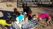
All locations: .0694823, .0841345
Globalhash:
-77.493177829398,-149.711587407140
Photo Gallery
Expeditions and Plans
| 2013-12-25 | ||
|---|---|---|
| Santa Ana, California | LucasBrown, his sister | On the northeast side of Bernardo Mountain, just downhill from the Bernardo... |
| Ridgecrest, California | Bravissimo594, Boppy5 | About 20 km north of Barstow ... somewhere in BLM desert land. Ridgecrest g... |
| Tehachapi, California | Bravissimo594, Boppy5 | A point in the Mojave desert west of California City -- BLM land. Tehachapi... |
| Bakersfield, California | Bravissimo594, Boppy5 | An agricultural field east of Maricopa, CA, near State Route 166 and n... |
| Eugene, Oregon | Someone went | The logical, reasonable place to spend Christmas day! On the golf links of... |
| Port Alberni, British Columbia | Rex Wolf | In a field or clearing south of the Nanaimo River, near South Nanaimo River... |