2014-01-07 37 -122
| Tue 7 Jan 2014 in 37,-122: 37.9105326, -122.1263144 geohashing.info google osm bing/os kml crox |
Location
In Briones Park near Lafayette, CA.
Participants
Plans
Expedition
Beejjorgenson
First one for me! Nice day in Briones Park...
Codae
This was certainly a day of wrong turns. First was when I forgot which road crossed Highway 24 to get to the park--I tried about three streets before finding the right one. Then, along the road that actually went to the appropriate staging area, I found that a sign for a cul-de-sac branching off to the right (and downwards--the region is pretty hilly) was in fact closer to the level of the left fork. Thus I mistook the road I wanted for a private no-outlet road and vice versa.
Once I got to the trailhead, I noticed a couple of people walking their three dogs along the trail, so I followed them. There was another trail heading more directly up the hill, but I'd not bothered to remember any of the park layout besides the route I was planning to follow, so I took it for a false trail. After all, the people were where I was. Once I got lost, I pulled out my laptop to check the hypothesis that the trailhead did have two trails branching off of it, the one I'd wanted and the one I'd taken, and found it to be true. I plotted a more circuitous route to the geohash, adding the better part of a mile to the hike.
I'd known the geohash was off the trail a bit, but when you're off the Lafayette Ridge Trail a bit it means you're pretty far downhill. In this case, that hill was quite dry and crumbly. I attempted a descent (without my webcam, even), and found the prospect of ascending from any farther down unappealing, so I gave up and returned home. At least I made all the right turns on the way back.
Tracklog
Photos
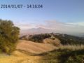
The path ahead, as seen from the highest point on the trek. Mt. Diablo is in the background.
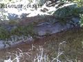
As close as I could get, given the slope that would look a lot steeper if the camera weren't angled downward.
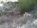
Then I decided that this very different slope was a little closer.
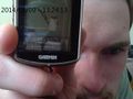
In the confusion over which slope was the best I could do, I forgot to get a picture of the GPS there. So this after-the-fact image of the GPS's mapping function is the best I can do. I think I got a little closer than last week.


Achievements
Codae
This user earned the Cliffs of Despair consolation prize
|