2014-01-26 38 -122
| Sun 26 Jan 2014 in 38,-122: 38.0104337, -122.5536921 geohashing.info google osm bing/os kml crox |
Location
Right by a street in San Rafael, California.
Participants
Plans
Bus to the location (conveniently, actually on a bus route) and bus back.
Expedition
The bus rides went mostly as planned, the exception being the transfer from the first leg to the second, to which the first bus was late. I thus had to wait an hour for the next ride out. Luckily, I came prepared for downtime: before I left, I had downloaded to my laptop several pages of That Wacky Redhead, an alternate history of pop culture I had started reading the day before. As a consequence of that reading, I had looked up the to-me mysterious initialization "ILM" (used fluently by commenters), which turned out to be George Lucas's postproduction studio, Industrial Light and Magic. Wikipedia further told me about how ILM had originally been headquartered in San Rafael, in a building disingenuously labeled "Kerner Co.", which I thought was an interesting story.
I occupied my bus rides as well as my waiting periods in reading, with only occasional lapses (for instance, when heading across the San Francisco Bay). At one point, though, I looked up and noticed a sign marking the "Kerner Building". The name rang a bell. Then I realized I was in San Rafael, and probably close to the very sign that had (mis)labeled Industrial Light and Magic. Sure enough, it showed up by the side of the road a moment later. (I was not prepared enough to get a picture, and, since Kerner Boulevard is one-way, I didn't pass the location on my way back. Just stumbling across the sign of which I'd read recently was fun enough, though.)
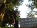
The third bus I got on was on the route right past the geohash. Displaying an intuition for bus stop locations unusual for me, I identified the last stop before my target and disembarked there, then walked the rest of the way (less than 200 meters). Getting within the maximum precision of my GPS wasn't hard, but, thanks to it being midafteroon instead of midday (as in my previous expedition), it was even harder to get a good shot of the reading with my webcam. Conveniently, a passerby happened upon me attempting to do so anyway. I say "conveniently" because it was her idea to photograph me at the nearest distinctive landmark--the sign for St. Isabella's Catholic Church and School--instead.
With this task completed, we parted and I returned home the same way I had arrived.
Tracklog
Photos
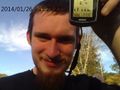
Well, it turns out this picture (#14 of 31 like it) was good enough. I just couldn't tell at the time.
I don't earn a Holy Hash for this, despite appearances, since the geohash was clearly outside the church lot.


Achievements
Codae earned the Land geohash achievement
|
Codae earned the Public transport geohash achievement
|
Codae achieved level 1 of the Minesweeper Geohash achievement
|